Bargersville geodata
Bargersville (Indiana) is a populated place; located in United States in America/Indiana/Indianapolis (GMT-4) time zone. With population of 6,846 people, there are 5897 cities with bigger population in this country. Compared to other cities in United States, 50.7% of cities are located further ↑North; 52.4% of cities are located further ←West and 62.8% of cities have lower elevation than Bargersville. Note1
Administrative division(s):
- Level 1: Indiana
- Level 2: Johnson County
- Level 3: Township of White River


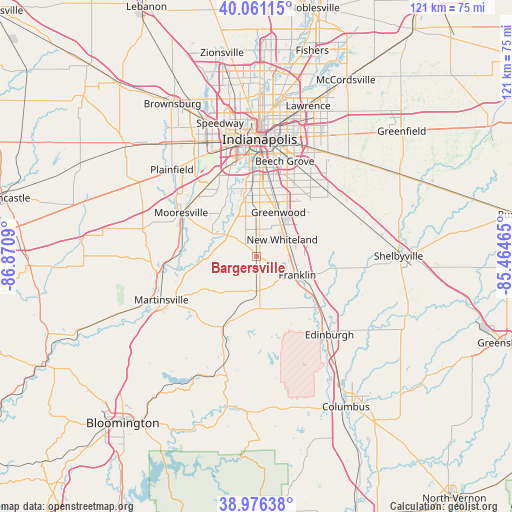
Bargersville GPS coordinates[2]
39° 31' 15.168" North, 86° 10' 3.972" West
| Map corner | latitude | longitude |
|---|---|---|
| Upper-left | 40.06115°, | -86.8709° |
| Center: | 39.52088°, | -86.16777° |
| Lower-right: | 38.97638°, | -85.46465° |
| Map W x H: | 120.6×120.6 km | = 74.9×74.9mi |
| max Lat: | 71.29058° ⇑50.7% North |
| Bargersville: | 39.52088° |
| min Lat: | ⇓49.3% South 19.06759° |
| min Long | Bargersville | max Long |
| -171.73463° | -86.16777° | -66.98998° |
| W 52.4%⇐ | ⇒47.6% E |
Elevation
Elevation of Bargersville is 252 m = 827 ft, and this is 42.8 m = 140 ft below average elevation for this country.
| Max E: |
3189 m = 10463 ft | 37.2% |
| Avg. | 294.8 m = 967 ft | |
| Bargersville | 252 m = 827 ft | |
Min E: |
-60 m = -197 ft | 62.8% |
See also: United States elevation on elevation.city.
Geographical zone
Bargersville is located in North temperate zone (between Tropic of Cancer and the Arctic Circle). Distance of this Northern Tropic circle is 1788.4 km =1111.3 mi to South.| Distance of | km | miles | from Bargersville |
|---|---|---|---|
| North Pole | 5612.8 | 3487.6 | to North |
| Arctic Circle | 3006.9 | 1868.4 | to North |
| Tropic Cancer | 1788.4 | 1111.3 | to South |
| Equator | 4394.3 | 2730.5 | to South |


Nearby cities:
15 places around Bargersville: (largest is in red/bold)
• Beech Grove
23.3 km =14.5 mi,  16°
16°
• Brooklyn
17.4 km =10.8 mi,  276°
276°
• Cordry Sweetwater Lakes
24.4 km =15.2 mi,  169°
169°
• Franklin
10.7 km =6.6 mi,  114°
114°
• Greenwood
11.6 km =7.2 mi,  26°
26°
• Homecroft
16.9 km =10.5 mi,  10°
10°
• Mooresville
20.4 km =12.7 mi,  300°
300°
• Morgantown
18.4 km =11.4 mi,  205°
205°
• New Whiteland
7.5 km =4.7 mi,  56°
56°
• Painted Hills
20.7 km =12.9 mi,  227°
227°
• Princes Lakes
19.5 km =12.1 mi,  162°
162°
• Southport
16.4 km =10.2 mi, 12°
• Trafalgar
11.7 km =7.3 mi, 172°
• Waterloo
5.3 km =3.3 mi,  331°
331°
• Whiteland
8.2 km =5.1 mi,  66°
66°
Sources, notices
• [Note1] Compared only with cities in United States existing in our database
• [Src1] Map data: © OpenStreetMap contributors (CC-BY-SA)
• [Src2] Other city data from geonames.org with taken over terms of usage.
• [Src3] Geographical zone / Annual Mean Temperature by Robert A. Rohde @ Wikipedia
