Washington Street Courthouse Annex geodata
Washington Street Courthouse Annex (Alabama) is a seat of a second-order administrative division; located in United States in America/Chicago (GMT-5) time zone. In our database, there are 21056 cities with bigger population. Compared to other cities in United States, 76.4% of cities are located further ↑North; 50.3% of cities are located further ←West and 54.4% of cities have lower elevation than Washington Street Courthouse Annex. Note1
Current local time in Washington Street Courthouse Annex:
08:10 AM, FridayDifference from your time zone: hours


Washington Street Courthouse Annex GPS coordinates[2]
34° 48' 9.504" North, 86° 58' 22.728" West
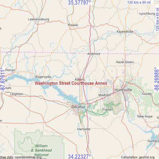
| Map corner | latitude | longitude |
|---|---|---|
| Upper-left | 35.37797°, | -87.67611° |
| Center: | 34.80264°, | -86.97298° |
| Lower-right: | 34.22327°, | -86.26986° |
| Map W x H: | 128.4×128.4 km | = 79.8×79.8mi |
| max Lat: | 71.29058° ⇑76.4% North |
| Washington Street Courthouse Annex: | 34.80264° |
| min Lat: | ⇓23.6% South 19.06759° |
| min Long | Washington Stre | max Long |
| -171.73463° | -86.97298° | -66.98998° |
| W 50.3%⇐ | ⇒49.7% E |
Elevation
Elevation of Washington Street Courthouse Annex is 216 m = 709 ft, and this is 78.8 m = 259 ft below average elevation for this country.
| Max E: |
3189 m = 10463 ft | 45.6% |
| Avg. | 294.8 m = 967 ft | |
| Washington Street Courthouse Annex | 216 m = 709 ft | |
Min E: |
-60 m = -197 ft | 54.4% |
See also: United States elevation on elevation.city.
Geographical zone
Washington Street Courthouse Annex is located in North temperate zone (between Tropic of Cancer and the Arctic Circle). Distance of this Northern Tropic circle is 1263.8 km =785.3 mi to South.| Distance of | km | miles | from Washington Street Courthouse Annex |
|---|---|---|---|
| North Pole | 6137.4 | 3813.6 | to North |
| Arctic Circle | 3531.5 | 2194.4 | to North |
| Tropic Cancer | 1263.8 | 785.3 | to South |
| Equator | 3869.7 | 2404.5 | to South |


Nearby cities:
15 places around Washington Street Courthouse Annex: (largest is in red/bold)
• Ardmore
24 km =14.9 mi,  28°
28°
• Athens
0.1 km =0.1 mi,  107°
107°
• Courtland
34.1 km =21.2 mi,  244°
244°
• Decatur
21.9 km =13.6 mi,  182°
182°
• Elkton
28.8 km =17.9 mi,  15°
15°
• Flint City
31.1 km =19.3 mi, 179°
• Harvest
21.1 km =13.1 mi,  73°
73°
• Hillsboro
27 km =16.8 mi,  227°
227°
• Madison
23.5 km =14.6 mi,  119°
119°
• Minor Hill
32.8 km =20.4 mi,  329°
329°
• Priceville
31.7 km =19.7 mi,  166°
166°
• Redstone Arsenal
32.5 km =20.2 mi, 113°
• Rogersville
29.7 km =18.5 mi,  274°
274°
• Triana
32.5 km =20.2 mi,  137°
137°
• Trinity
24.2 km =15 mi,  205°
205°
Sources, notices
• [Note1] Compared only with cities in United States existing in our database
• [Src1] Map data: © OpenStreetMap contributors (CC-BY-SA)
• [Src2] Other city data from geonames.org with taken over terms of usage.
• [Src3] Geographical zone / Annual Mean Temperature by Robert A. Rohde @ Wikipedia
