Harvest geodata
Harvest (Alabama) is a populated place; located in United States in America/Chicago (GMT-5) time zone. With population of 5,281 people, there are 6930 cities with bigger population in this country. Compared to other cities in United States, 76.1% of cities are located further ↑North; 50.9% of cities are located further ←West and 63.1% of cities have lower elevation than Harvest. Note1


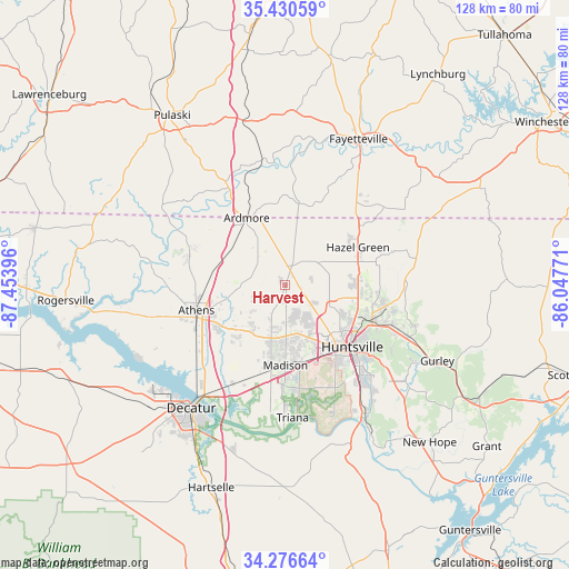
Harvest GPS coordinates[2]
34° 51' 20.304" North, 86° 45' 2.988" West
| Map corner | latitude | longitude |
|---|---|---|
| Upper-left | 35.43059°, | -87.45396° |
| Center: | 34.85564°, | -86.75083° |
| Lower-right: | 34.27664°, | -86.04771° |
| Map W x H: | 128.3×128.3 km | = 79.7×79.7mi |
| max Lat: | 71.29058° ⇑76.1% North |
| Harvest: | 34.85564° |
| min Lat: | ⇓23.9% South 19.06759° |
| min Long | Harvest | max Long |
| -171.73463° | -86.75083° | -66.98998° |
| W 50.9%⇐ | ⇒49.1% E |
Elevation
Elevation of Harvest is 253 m = 830 ft, and this is 41.8 m = 137 ft below average elevation for this country.
| Max E: |
3189 m = 10463 ft | 36.9% |
| Avg. | 294.8 m = 967 ft | |
| Harvest | 253 m = 830 ft | |
Min E: |
-60 m = -197 ft | 63.1% |
See also: United States elevation on elevation.city.
Geographical zone
Harvest is located in North temperate zone (between Tropic of Cancer and the Arctic Circle). Distance of this Northern Tropic circle is 1269.7 km =789 mi to South.| Distance of | km | miles | from Harvest |
|---|---|---|---|
| North Pole | 6131.5 | 3809.9 | to North |
| Arctic Circle | 3525.6 | 2190.7 | to North |
| Tropic Cancer | 1269.7 | 789 | to South |
| Equator | 3875.6 | 2408.2 | to South |


Nearby cities:
15 places around Harvest: (largest is in red/bold)
• Ardmore
17.5 km =10.9 mi,  330°
330°
• Athens
21.1 km =13.1 mi,  253°
253°
• Decatur
35 km =21.7 mi,  217°
217°
• Elkton
25.2 km =15.7 mi, 330°
• Fayetteville
36.8 km =22.9 mi,  26°
26°
• Hazel Green
18.4 km =11.4 mi,  62°
62°
• Huntsville
20.5 km =12.7 mi,  132°
132°
• Madison
17.4 km =10.8 mi,  179°
179°
• Meridianville
16.3 km =10.1 mi,  91°
91°
• Moores Mill
21.3 km =13.2 mi, 93°
• New Market
30.1 km =18.7 mi,  78°
78°
• Park City
30 km =18.6 mi, 33°
• Redstone Arsenal
21.3 km =13.2 mi,  153°
153°
• Triana
30 km =18.6 mi, 176°
• Washington Street Courthouse Annex
21.1 km =13.1 mi, 253°
Sources, notices
• [Note1] Compared only with cities in United States existing in our database
• [Src1] Map data: © OpenStreetMap contributors (CC-BY-SA)
• [Src2] Other city data from geonames.org with taken over terms of usage.
• [Src3] Geographical zone / Annual Mean Temperature by Robert A. Rohde @ Wikipedia
