Redstone Arsenal geodata
Redstone Arsenal (Alabama) is a populated place; located in United States in America/Chicago (GMT-5) time zone. With population of 1,946 people, there are 12107 cities with bigger population in this country. Compared to other cities in United States, 76.9% of cities are located further ↑North; 51.2% of cities are located further ←West and 75.4% of cities have lower elevation than Redstone Arsenal. Note1


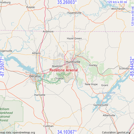
Redstone Arsenal GPS coordinates[2]
34° 41' 1.932" North, 86° 38' 51.504" West
| Map corner | latitude | longitude |
|---|---|---|
| Upper-left | 35.26003°, | -87.35077° |
| Center: | 34.68387°, | -86.64764° |
| Lower-right: | 34.10367°, | -85.94452° |
| Map W x H: | 128.6×128.6 km | = 79.9×79.9mi |
| max Lat: | 71.29058° ⇑76.9% North |
| Redstone Arsenal: | 34.68387° |
| min Lat: | ⇓23.1% South 19.06759° |
| min Long | Redstone Arsena | max Long |
| -171.73463° | -86.64764° | -66.98998° |
| W 51.2%⇐ | ⇒48.8% E |
Elevation
Elevation of Redstone Arsenal is 316 m = 1037 ft, and this is 21.2 m = 70 ft above average elevation for this country.
| Max E: |
3189 m = 10463 ft | 24.6% |
| Redstone Arsenal | 316 m 1037 ft | |
| Avg. | 294.8 m = 967 ft | |
Min E: |
-60 m = -197 ft | 75.4% |
See also: United States elevation on elevation.city.
Geographical zone
Redstone Arsenal is located in North temperate zone (between Tropic of Cancer and the Arctic Circle). Distance of this Northern Tropic circle is 1250.6 km =777.1 mi to South.| Distance of | km | miles | from Redstone Arsenal |
|---|---|---|---|
| North Pole | 6150.6 | 3821.8 | to North |
| Arctic Circle | 3544.7 | 2202.6 | to North |
| Tropic Cancer | 1250.6 | 777.1 | to South |
| Equator | 3856.5 | 2396.3 | to South |


Nearby cities:
15 places around Redstone Arsenal: (largest is in red/bold)
• Athens
32.5 km =20.2 mi,  293°
293°
• Decatur
31.9 km =19.8 mi,  254°
254°
• Gurley
24.9 km =15.5 mi,  85°
85°
• Harvest
21.3 km =13.2 mi,  333°
333°
• Hazel Green
28.5 km =17.7 mi,  14°
14°
• Huntsville
7.7 km =4.8 mi,  47°
47°
• Madison
9.4 km =5.8 mi,  280°
280°
• Meridianville
19.9 km =12.4 mi,  20°
20°
• Moores Mill
21.4 km =13.3 mi,  33°
33°
• New Hope
28.4 km =17.6 mi,  125°
125°
• New Market
32.2 km =20 mi,  38°
38°
• Owens Cross Roads
20.3 km =12.6 mi,  121°
121°
• Priceville
28.7 km =17.8 mi,  232°
232°
• Somerville
27.2 km =16.9 mi,  210°
210°
• Triana
13.4 km =8.3 mi,  215°
215°
Sources, notices
• [Note1] Compared only with cities in United States existing in our database
• [Src1] Map data: © OpenStreetMap contributors (CC-BY-SA)
• [Src2] Other city data from geonames.org with taken over terms of usage.
• [Src3] Geographical zone / Annual Mean Temperature by Robert A. Rohde @ Wikipedia
