Oqoltin geodata
Oqoltin (Andijon) is a seat of a second-order administrative division; located in Uzbekistan in Asia/Tashkent (GMT+5) time zone. In our database, there are 114 cities with bigger population. Compared to other cities in Uzbekistan, 57.5% of cities are located further ↓South; 82.8% of cities are located further ←West and 54% of cities have higher elevation than Oqoltin. Note1


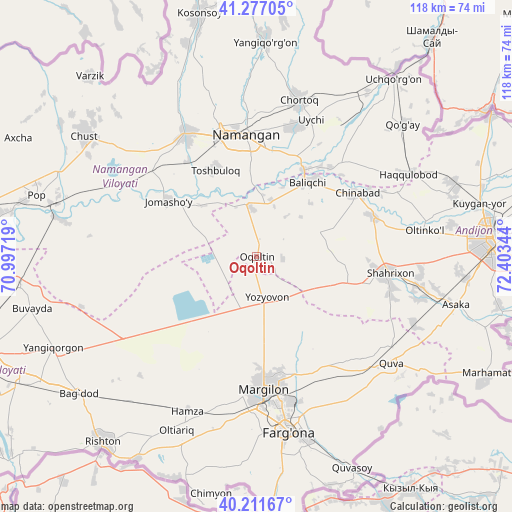
Oqoltin GPS coordinates[2]
40° 44' 47.364" North, 71° 42' 1.116" East
| Map corner | latitude | longitude |
|---|---|---|
| Upper-left | 41.27705°, | 70.99719° |
| Center: | 40.74649°, | 71.70031° |
| Lower-right: | 40.21167°, | 72.40344° |
| Map W x H: | 118.5×118.5 km | = 73.6×73.6mi |
| max Lat: | 43.77877° ⇑42.5% North |
| Oqoltin: | 40.74649° |
| min Lat: | ⇓57.5% South 37.22417° |
| min Long | Oqoltin | max Long |
| 58.84596° | 71.70031° | 72.76177° |
| W 82.8%⇐ | ⇒17.2% E |
Elevation
Elevation of Oqoltin is 405 m = 1329 ft, and this is 28.8 m = 94 ft below average elevation for this country.
| Max E: |
1464 m = 4803 ft | 54% |
| Avg. | 433.8 m = 1423 ft | |
| Oqoltin | 405 m = 1329 ft | |
Min E: |
50 m = 164 ft | 46% |
See also: Uzbekistan elevation on elevation.city.
Geographical zone
Oqoltin is located in North temperate zone (between Tropic of Cancer and the Arctic Circle). Distance of this Northern Tropic circle is 1924.7 km =1196 mi to South.| Distance of | km | miles | from Oqoltin |
|---|---|---|---|
| North Pole | 5476.5 | 3402.9 | to North |
| Arctic Circle | 2870.6 | 1783.7 | to North |
| Tropic Cancer | 1924.7 | 1196 | to South |
| Equator | 4530.6 | 2815.2 | to South |


Nearby cities:
15 places around Oqoltin: (largest is in red/bold)
• Baliqchi
21.5 km =13.4 mi,  35°
35°
• Chortoq
37.4 km =23.2 mi,  16°
16°
• Chortoq Shahri
38.1 km =23.7 mi, 15°
• Hamza
39.1 km =24.3 mi,  204°
204°
• Kirguli
35 km =21.7 mi,  170°
170°
• Langar
25.4 km =15.8 mi,  187°
187°
• Marg‘ilon
30.5 km =19 mi,  176°
176°
• Namangan
28.1 km =17.5 mi,  355°
355°
• Shahrixon
30.3 km =18.8 mi,  96°
96°
• Toshbuloq
21.5 km =13.4 mi,  331°
331°
• Toshloq
30.5 km =19 mi, 169°
• To‘rqao‘rg‘on
32.3 km =20.1 mi, 330°
• Tŭragŭrghon Shahri
32.7 km =20.3 mi, 330°
• Yangi Marg‘ilon
35.5 km =22.1 mi, 177°
• Yozyovon
10.1 km =6.3 mi,  158°
158°
Sources, notices
• [Note1] Compared only with cities in Uzbekistan existing in our database
• [Src1] Map data: © OpenStreetMap contributors (CC-BY-SA)
• [Src2] Other city data from geonames.org with taken over terms of usage.
• [Src3] Geographical zone / Annual Mean Temperature by Robert A. Rohde @ Wikipedia
