Namangan geodata
Namangan is a seat of a first-order administrative division; located in Uzbekistan in Asia/Tashkent (GMT+5) time zone. With population of 432,456 people, there is 1 city with bigger population in this country. Compared to other cities in Uzbekistan, 67.8% of cities are located further ↓South; 82.2% of cities are located further ←West and 54% of cities have lower elevation than Namangan. Note1


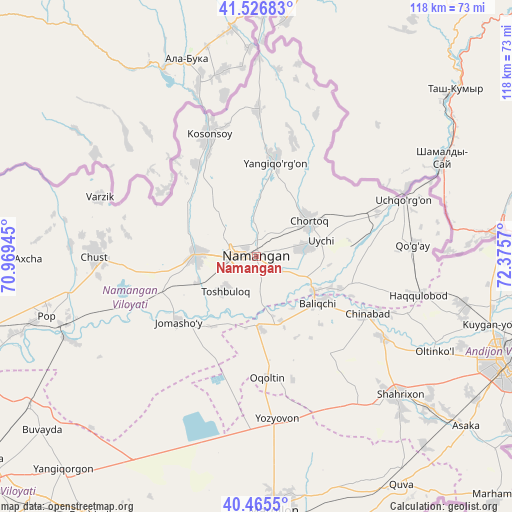
Namangan GPS coordinates[2]
40° 59' 53.88" North, 71° 40' 21.252" East
| Map corner | latitude | longitude |
|---|---|---|
| Upper-left | 41.52683°, | 70.96945° |
| Center: | 40.9983°, | 71.67257° |
| Lower-right: | 40.4655°, | 72.3757° |
| Map W x H: | 118×118 km | = 73.3×73.3mi |
| max Lat: | 43.77877° ⇑32.2% North |
| Namangan: | 40.9983° |
| min Lat: | ⇓67.8% South 37.22417° |
| min Long | Namangan | max Long |
| 58.84596° | 71.67257° | 72.76177° |
| W 82.2%⇐ | ⇒17.8% E |
Elevation
Elevation of Namangan is 442 m = 1450 ft, and this is 8.2 m = 27 ft above average elevation for this country.
| Max E: |
1464 m = 4803 ft | 46% |
| Namangan | 442 m 1450 ft | |
| Avg. | 433.8 m = 1423 ft | |
Min E: |
50 m = 164 ft | 54% |
See also: Namangan elevation on elevation.city.
Geographical zone
Namangan is located in North temperate zone (between Tropic of Cancer and the Arctic Circle). Distance of this Northern Tropic circle is 1952.7 km =1213.4 mi to South.| Distance of | km | miles | from Namangan |
|---|---|---|---|
| North Pole | 5448.5 | 3385.5 | to North |
| Arctic Circle | 2842.6 | 1766.3 | to North |
| Tropic Cancer | 1952.7 | 1213.4 | to South |
| Equator | 4558.6 | 2832.6 | to South |


Nearby cities:
15 places around Namangan: (largest is in red/bold)
• Baliqchi
18 km =11.2 mi,  125°
125°
• Chortoq
14.9 km =9.3 mi,  58°
58°
• Chortoq Shahri
15 km =9.3 mi,  54°
54°
• Chust
36.5 km =22.7 mi,  270°
270°
• Haqqulobod
38.4 km =23.9 mi,  103°
103°
• Kosonsoy
29.8 km =18.5 mi,  339°
339°
• Kosonsoy Shahri
31.4 km =19.5 mi, 339°
• Oqoltin
28.1 km =17.5 mi,  175°
175°
• Toshbuloq
12.1 km =7.5 mi,  220°
220°
• To‘rqao‘rg‘on
13.5 km =8.4 mi, 270°
• Tŭragŭrghon Shahri
13.6 km =8.5 mi, 272°
• Uchqŭrghon Shahri
36.4 km =22.6 mi,  69°
69°
• Uychi
22.9 km =14.2 mi, 66°
• Yangiqo‘rg‘on
22.3 km =13.9 mi,  11°
11°
• Yozyovon
37.9 km =23.5 mi,  170°
170°
Sources, notices
• [Note1] Compared only with cities in Uzbekistan existing in our database
• [Src1] Map data: © OpenStreetMap contributors (CC-BY-SA)
• [Src2] Other city data from geonames.org with taken over terms of usage.
• [Src3] Geographical zone / Annual Mean Temperature by Robert A. Rohde @ Wikipedia
