Kirguli geodata
Kirguli (Fergana) is a populated place; located in Uzbekistan in Asia/Tashkent (GMT+5) time zone. With population of 20,459 people, there are 81 cities with bigger population in this country. Compared to other cities in Uzbekistan, 57.5% of cities are located further ↑North; 86.2% of cities are located further ←West and 75.3% of cities have lower elevation than Kirguli. Note1


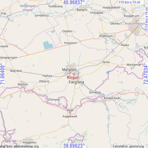
Kirguli GPS coordinates[2]
40° 26' 7.908" North, 71° 46' 1.956" East
| Map corner | latitude | longitude |
|---|---|---|
| Upper-left | 40.96857°, | 71.06409° |
| Center: | 40.43553°, | 71.76721° |
| Lower-right: | 39.89823°, | 72.47034° |
| Map W x H: | 119×119 km | = 73.9×73.9mi |
| max Lat: | 43.77877° ⇑57.5% North |
| Kirguli: | 40.43553° |
| min Lat: | ⇓42.5% South 37.22417° |
| min Long | Kirguli | max Long |
| 58.84596° | 71.76721° | 72.76177° |
| W 86.2%⇐ | ⇒13.8% E |
Elevation
Elevation of Kirguli is 547 m = 1795 ft, and this is 113.2 m = 371 ft above average elevation for this country.
| Max E: |
1464 m = 4803 ft | 24.7% |
| Kirguli | 547 m 1795 ft | |
| Avg. | 433.8 m = 1423 ft | |
Min E: |
50 m = 164 ft | 75.3% |
See also: Uzbekistan elevation on elevation.city.
Geographical zone
Kirguli is located in North temperate zone (between Tropic of Cancer and the Arctic Circle). Distance of this Northern Tropic circle is 1890.1 km =1174.5 mi to South.| Distance of | km | miles | from Kirguli |
|---|---|---|---|
| North Pole | 5511.1 | 3424.4 | to North |
| Arctic Circle | 2905.2 | 1805.2 | to North |
| Tropic Cancer | 1890.1 | 1174.5 | to South |
| Equator | 4496 | 2793.7 | to South |


Nearby cities:
15 places around Kirguli: (largest is in red/bold)
• Asaka
46 km =28.6 mi,  60°
60°
• Fergana
5.9 km =3.7 mi,  165°
165°
• Hamza
22.2 km =13.8 mi,  267°
267°
• Langar
13.1 km =8.1 mi,  316°
316°
• Marg‘ilon
5.5 km =3.4 mi, 318°
• Oltiariq
25.3 km =15.7 mi,  258°
258°
• Oqoltin
35 km =21.7 mi,  350°
350°
• Quva
27.6 km =17.1 mi,  69°
69°
• Quvasoy
23.7 km =14.7 mi,  130°
130°
• Rishton
41.8 km =26 mi, 257°
• Shahrixon
39.4 km =24.5 mi,  38°
38°
• Toshloq
4.6 km =2.9 mi,  0°
0°
• Vodil
29.2 km =18.1 mi,  186°
186°
• Yangi Marg‘ilon
4.2 km =2.6 mi, 257°
• Yozyovon
25.2 km =15.7 mi,  355°
355°
Sources, notices
• [Note1] Compared only with cities in Uzbekistan existing in our database
• [Src1] Map data: © OpenStreetMap contributors (CC-BY-SA)
• [Src2] Other city data from geonames.org with taken over terms of usage.
• [Src3] Geographical zone / Annual Mean Temperature by Robert A. Rohde @ Wikipedia
