San Pedro de Coche geodata
San Pedro de Coche (Nueva Esparta) is a seat of a second-order administrative division; located in Venezuela in America/Caracas (GMT-4) time zone. In our database, there are 108 cities with bigger population. Compared to other cities in Venezuela, 90.6% of cities are located further ↓South; 87.5% of cities are located further ←West and 96.9% of cities have higher elevation than San Pedro de Coche. Note1


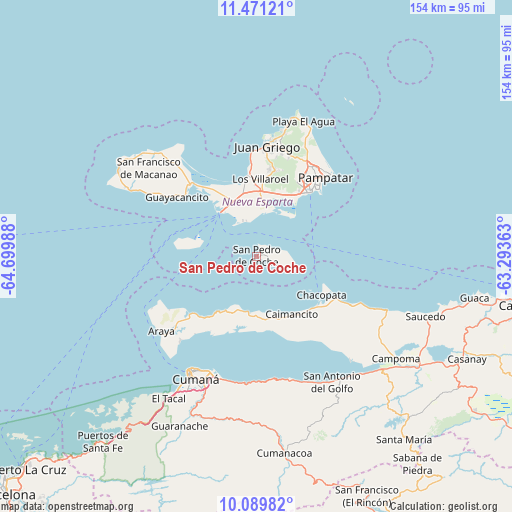
San Pedro de Coche GPS coordinates[2]
10° 46' 52.716" North, 63° 59' 48.3" West
| Map corner | latitude | longitude |
|---|---|---|
| Upper-left | 11.47121°, | -64.69988° |
| Center: | 10.78131°, | -63.99675° |
| Lower-right: | 10.08982°, | -63.29363° |
| Map W x H: | 153.6×153.6 km | = 95.4×95.4mi |
| max Lat: | 11.94788° ⇑9.4% North |
| San Pedro de Coche: | 10.78131° |
| min Lat: | ⇓90.6% South 1.92027° |
| min Long | San Pedro de Co | max Long |
| -72.55212° | -63.99675° | -60.99778° |
| W 87.5%⇐ | ⇒12.5% E |
Elevation
Elevation of San Pedro de Coche is 2 m = 7 ft, and this is 378.6 m = 1242 ft below average elevation for this country.
| Max E: |
2986 m = 9797 ft | 96.9% |
| Avg. | 380.6 m = 1249 ft | |
| San Pedro de Coche | 2 m = 7 ft | |
Min E: |
-4 m = -13 ft | 3.1% |
See also: Venezuela elevation on elevation.city.
Geographical zone
San Pedro de Coche is located in North Torrid zone (between Equator and Tropic of Cancer). Distance of Equator is 1198.8 km =744.9 mi to South.| Distance of | km | miles | from San Pedro de Coche |
|---|---|---|---|
| North Pole | 8808.3 | 5473.2 | to North |
| Arctic Circle | 6202.4 | 3854 | to North |
| Tropic Cancer | 1407.1 | 874.3 | to North |
| Equator | 1198.8 | 744.9 | to South |


Nearby cities:
15 places around San Pedro de Coche: (largest is in red/bold)
• Araya
36.1 km =22.4 mi,  231°
231°
• Boca de Río
28.8 km =17.9 mi,  315°
315°
• Cariaco
57.9 km =36 mi,  123°
123°
• Cumaná
41.7 km =25.9 mi,  209°
209°
• El Valle del Espíritu Santo
25.7 km =16 mi,  28°
28°
• Juan Griego
33.6 km =20.9 mi,  5°
5°
• La Asunción
31.6 km =19.6 mi, 27°
• La Plaza Paraguachi
39.5 km =24.5 mi,  23°
23°
• Marigüitar
38.5 km =23.9 mi,  164°
164°
• Pampatar
33.1 km =20.6 mi,  42°
42°
• Porlamar
24 km =14.9 mi, 35°
• Punta de Piedras
17.2 km =10.7 mi, 320°
• San Antonio del Golfo
44 km =27.3 mi,  148°
148°
• San Juan Bautista
26.5 km =16.5 mi, 12°
• Santa Ana
32.9 km =20.4 mi, 14°
Sources, notices
• [Note1] Compared only with cities in Venezuela existing in our database
• [Src1] Map data: © OpenStreetMap contributors (CC-BY-SA)
• [Src2] Other city data from geonames.org with taken over terms of usage.
• [Src3] Geographical zone / Annual Mean Temperature by Robert A. Rohde @ Wikipedia
