Araya geodata
Araya (Sucre) is a seat of a second-order administrative division; located in Venezuela in America/Caracas (GMT-4) time zone. In our database, there are 108 cities with bigger population. Compared to other cities in Venezuela, 86.3% of cities are located further ↓South; 86% of cities are located further ←West and 82.7% of cities have higher elevation than Araya. Note1


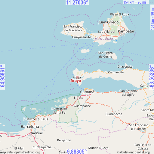
Araya GPS coordinates[2]
10° 34' 47.928" North, 64° 15' 19.728" West
| Map corner | latitude | longitude |
|---|---|---|
| Upper-left | 11.27036°, | -64.95861° |
| Center: | 10.57998°, | -64.25548° |
| Lower-right: | 9.88805°, | -63.55236° |
| Map W x H: | 153.7×153.7 km | = 95.5×95.5mi |
| max Lat: | 11.94788° ⇑13.7% North |
| Araya: | 10.57998° |
| min Lat: | ⇓86.3% South 1.92027° |
| min Long | Araya | max Long |
| -72.55212° | -64.25548° | -60.99778° |
| W 86%⇐ | ⇒14% E |
Elevation
Elevation of Araya is 40 m = 131 ft, and this is 340.6 m = 1117 ft below average elevation for this country.
| Max E: |
2986 m = 9797 ft | 82.7% |
| Avg. | 380.6 m = 1249 ft | |
| Araya | 40 m = 131 ft | |
Min E: |
-4 m = -13 ft | 17.3% |
See also: Venezuela elevation on elevation.city.
Geographical zone
Araya is located in North Torrid zone (between Equator and Tropic of Cancer). Distance of Equator is 1176.4 km =731 mi to South.| Distance of | km | miles | from Araya |
|---|---|---|---|
| North Pole | 8830.7 | 5487.1 | to North |
| Arctic Circle | 6224.8 | 3867.9 | to North |
| Tropic Cancer | 1429.5 | 888.2 | to North |
| Equator | 1176.4 | 731 | to South |


Nearby cities:
15 places around Araya: (largest is in red/bold)
• Boca de Río
43.9 km =27.3 mi,  10°
10°
• Cumanacoa
51.9 km =32.2 mi,  134°
134°
• Cumaná
16.1 km =10 mi,  150°
150°
• El Valle del Espíritu Santo
60.5 km =37.6 mi,  42°
42°
• Guanta
53.6 km =33.3 mi,  224°
224°
• Juan Griego
64.2 km =39.9 mi,  29°
29°
• Lecherías
64.4 km =40 mi,  227°
227°
• Marigüitar
41.4 km =25.7 mi,  110°
110°
• Porlamar
59.5 km =37 mi,  45°
45°
• Puerto La Cruz
58 km =36 mi, 225°
• Punta de Piedras
39.7 km =24.7 mi, 25°
• San Antonio del Golfo
53.3 km =33.1 mi, 106°
• San Juan Bautista
59.1 km =36.7 mi, 35°
• San Pedro de Coche
36.1 km =22.4 mi, 51°
• Santa Ana
65.4 km =40.6 mi, 33°
Sources, notices
• [Note1] Compared only with cities in Venezuela existing in our database
• [Src1] Map data: © OpenStreetMap contributors (CC-BY-SA)
• [Src2] Other city data from geonames.org with taken over terms of usage.
• [Src3] Geographical zone / Annual Mean Temperature by Robert A. Rohde @ Wikipedia
