Cumaná geodata
Cumaná (Sucre) is a seat of a first-order administrative division; located in Venezuela in America/Caracas (GMT-4) time zone. With population of 257,783 people, there are 16 cities with bigger population in this country. Compared to other cities in Venezuela, 79.6% of cities are located further ↓South; 86.5% of cities are located further ←West and 95.2% of cities have higher elevation than Cumaná. Note1


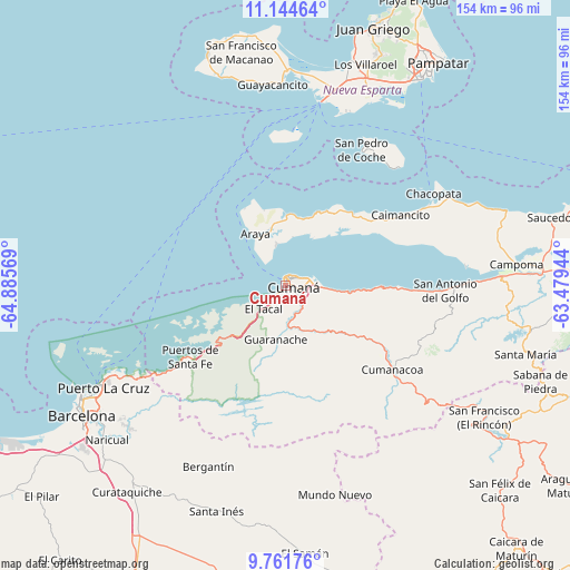
Cumaná GPS coordinates[2]
10° 27' 14.292" North, 64° 10' 57.216" West
| Map corner | latitude | longitude |
|---|---|---|
| Upper-left | 11.14464°, | -64.88569° |
| Center: | 10.45397°, | -64.18256° |
| Lower-right: | 9.76176°, | -63.47944° |
| Map W x H: | 153.8×153.8 km | = 95.6×95.6mi |
| max Lat: | 11.94788° ⇑20.4% North |
| Cumaná: | 10.45397° |
| min Lat: | ⇓79.6% South 1.92027° |
| min Long | Cumaná | max Long |
| -72.55212° | -64.18256° | -60.99778° |
| W 86.5%⇐ | ⇒13.5% E |
Elevation
Elevation of Cumaná is 4 m = 13 ft, and this is 376.6 m = 1236 ft below average elevation for this country.
| Max E: |
2986 m = 9797 ft | 95.2% |
| Avg. | 380.6 m = 1249 ft | |
| Cumaná | 4 m = 13 ft | |
Min E: |
-4 m = -13 ft | 4.8% |
See also: Cumaná elevation on elevation.city.
Geographical zone
Cumaná is located in North Torrid zone (between Equator and Tropic of Cancer). Distance of Equator is 1162.4 km =722.3 mi to South.| Distance of | km | miles | from Cumaná |
|---|---|---|---|
| North Pole | 8844.7 | 5495.8 | to North |
| Arctic Circle | 6238.8 | 3876.6 | to North |
| Tropic Cancer | 1443.5 | 896.9 | to North |
| Equator | 1162.4 | 722.3 | to South |


Nearby cities:
15 places around Cumaná: (largest is in red/bold)
• Araya
16.1 km =10 mi,  330°
330°
• Barcelona
65.4 km =40.6 mi,  237°
237°
• Boca de Río
57.1 km =35.5 mi,  0°
0°
• Cumanacoa
36.6 km =22.7 mi,  128°
128°
• El Valle del Espíritu Santo
67.3 km =41.8 mi,  29°
29°
• Guanta
51.5 km =32 mi, 241°
• Lecherías
62.9 km =39.1 mi, 242°
• Marigüitar
30.7 km =19.1 mi,  91°
91°
• Porlamar
65.6 km =40.8 mi, 31°
• Puerto La Cruz
56 km =34.8 mi, 241°
• Punta de Piedras
50.6 km =31.4 mi,  10°
10°
• San Antonio
62.4 km =38.8 mi, 126°
• San Antonio del Golfo
43.1 km =26.8 mi, 91°
• San Juan Bautista
67.5 km =41.9 mi,  22°
22°
• San Pedro de Coche
41.7 km =25.9 mi, 29°
Sources, notices
• [Note1] Compared only with cities in Venezuela existing in our database
• [Src1] Map data: © OpenStreetMap contributors (CC-BY-SA)
• [Src2] Other city data from geonames.org with taken over terms of usage.
• [Src3] Geographical zone / Annual Mean Temperature by Robert A. Rohde @ Wikipedia
