San Carlos de Río Negro geodata
San Carlos de Río Negro (Amazonas) is a seat of a second-order administrative division; located in Venezuela in America/Caracas (GMT-4) time zone. In our database, there are 108 cities with bigger population. Compared to other cities in Venezuela, 100% of cities are located further ↑North; 67.7% of cities are located further ←West and 68.2% of cities have higher elevation than San Carlos de Río Negro. Note1
Current local time in San Carlos de Río Negro:
02:07 PM, ThursdayDifference from your time zone: hours


San Carlos de Río Negro GPS coordinates[2]
1° 55' 12.972" North, 67° 3' 39.204" West
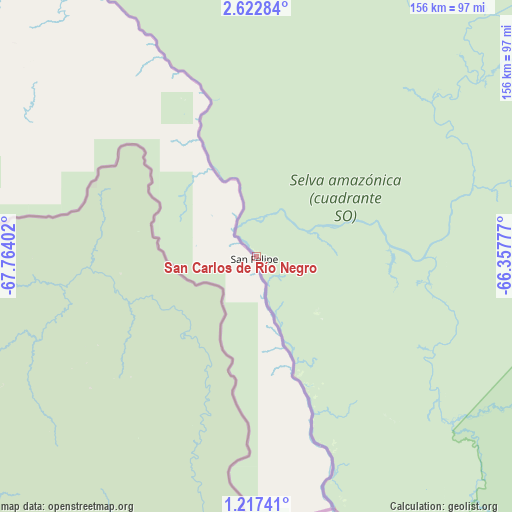
| Map corner | latitude | longitude |
|---|---|---|
| Upper-left | 2.62284°, | -67.76402° |
| Center: | 1.92027°, | -67.06089° |
| Lower-right: | 1.21741°, | -66.35777° |
| Map W x H: | 156.3×156.3 km | = 97.1×97.1mi |
| max Lat: | 11.94788° ⇑100% North |
| San Carlos de Río Negro: | 1.92027° |
| min Lat: | ⇓0% South 1.92027° |
| min Long | San Carlos de R | max Long |
| -72.55212° | -67.06089° | -60.99778° |
| W 67.7%⇐ | ⇒32.3% E |
Elevation
Elevation of San Carlos de Río Negro is 92 m = 302 ft, and this is 288.6 m = 947 ft below average elevation for this country.
| Max E: |
2986 m = 9797 ft | 68.2% |
| Avg. | 380.6 m = 1249 ft | |
| San Carlos de Río Negro | 92 m = 302 ft | |
Min E: |
-4 m = -13 ft | 31.8% |
See also: Venezuela elevation on elevation.city.
Geographical zone
San Carlos de Río Negro is located in North Torrid zone (between Equator and Tropic of Cancer). Distance of Equator is 213.5 km =132.7 mi to South.| Distance of | km | miles | from San Carlos de Río Negro |
|---|---|---|---|
| North Pole | 9793.5 | 6085.4 | to North |
| Arctic Circle | 7187.7 | 4466.2 | to North |
| Tropic Cancer | 2392.4 | 1486.6 | to North |
| Equator | 213.5 | 132.7 | to South |


Nearby cities:
6 places around San Carlos de Río Negro: (largest is in red/bold)
• Isla Ratón
359.9 km =223.6 mi,  346°
346°
• La Esmeralda
218.6 km =135.8 mi,  50°
50°
• Maroa
104.7 km =65.1 mi,  327°
327°
• Puerto Ayacucho
419.9 km =260.9 mi, 352°
• San Fernando de Atabapo
246.7 km =153.3 mi,  343°
343°
• San Juan de Manapiare
394.9 km =245.4 mi,  16°
16°
Sources, notices
• [Note1] Compared only with cities in Venezuela existing in our database
• [Src1] Map data: © OpenStreetMap contributors (CC-BY-SA)
• [Src2] Other city data from geonames.org with taken over terms of usage.
• [Src3] Geographical zone / Annual Mean Temperature by Robert A. Rohde @ Wikipedia
