Puerto Ayacucho geodata
Puerto Ayacucho (Amazonas) is a seat of a first-order administrative division; located in Venezuela in America/Caracas (GMT-4) time zone. With population of 52,526 people, there are 74 cities with bigger population in this country. Compared to other cities in Venezuela, 98.2% of cities are located further ↑North; 62.6% of cities are located further ←West and 70.5% of cities have higher elevation than Puerto Ayacucho. Note1


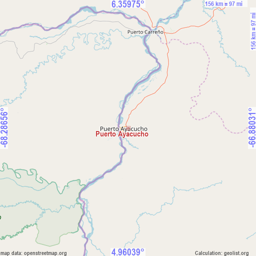
Puerto Ayacucho GPS coordinates[2]
5° 39' 37.764" North, 67° 35' 0.348" West
| Map corner | latitude | longitude |
|---|---|---|
| Upper-left | 6.35975°, | -68.28656° |
| Center: | 5.66049°, | -67.58343° |
| Lower-right: | 4.96039°, | -66.88031° |
| Map W x H: | 155.6×155.6 km | = 96.7×96.7mi |
| max Lat: | 11.94788° ⇑98.2% North |
| Puerto Ayacucho: | 5.66049° |
| min Lat: | ⇓1.8% South 1.92027° |
| min Long | Puerto Ayacucho | max Long |
| -72.55212° | -67.58343° | -60.99778° |
| W 62.6%⇐ | ⇒37.4% E |
Elevation
Elevation of Puerto Ayacucho is 84 m = 276 ft, and this is 296.6 m = 973 ft below average elevation for this country.
| Max E: |
2986 m = 9797 ft | 70.5% |
| Avg. | 380.6 m = 1249 ft | |
| Puerto Ayacucho | 84 m = 276 ft | |
Min E: |
-4 m = -13 ft | 29.5% |
See also: Puerto Ayacucho elevation on elevation.city.
Geographical zone
Puerto Ayacucho is located in North Torrid zone (between Equator and Tropic of Cancer). Distance of Equator is 629.4 km =391.1 mi to South.| Distance of | km | miles | from Puerto Ayacucho |
|---|---|---|---|
| North Pole | 9377.7 | 5827 | to North |
| Arctic Circle | 6771.8 | 4207.8 | to North |
| Tropic Cancer | 1976.5 | 1228.1 | to North |
| Equator | 629.4 | 391.1 | to South |


Nearby cities:
15 places around Puerto Ayacucho: (largest is in red/bold)
• Achaguas
246 km =152.9 mi,  343°
343°
• Biruaca
243 km =151 mi,  1°
1°
• Caicara del Orinoco
269.5 km =167.5 mi,  35°
35°
• Camaguán
272.1 km =169.1 mi,  359°
359°
• Elorza
262.7 km =163.2 mi,  306°
306°
• Guadarrama
323.7 km =201.1 mi,  350°
350°
• Guayabal
261 km =162.2 mi, 4°
• Isla Ratón
70.5 km =43.8 mi,  201°
201°
• La Unión
284.8 km =177 mi, 355°
• San Antonio
272.8 km =169.5 mi, 339°
• San Fernando de Apure
248 km =154.1 mi, 2°
• San Fernando de Atabapo
180 km =111.8 mi,  184°
184°
• San Juan de Manapiare
173.3 km =107.7 mi,  102°
102°
• San Juan de Payara
220.8 km =137.2 mi, 359°
• Santa Catalina
291.6 km =181.2 mi,  329°
329°
Sources, notices
• [Note1] Compared only with cities in Venezuela existing in our database
• [Src1] Map data: © OpenStreetMap contributors (CC-BY-SA)
• [Src2] Other city data from geonames.org with taken over terms of usage.
• [Src3] Geographical zone / Annual Mean Temperature by Robert A. Rohde @ Wikipedia
