San Felipe geodata
San Felipe (Yaracuy) is a seat of a first-order administrative division; located in Venezuela in America/Caracas (GMT-4) time zone. With population of 76,766 people, there are 54 cities with bigger population in this country. Compared to other cities in Venezuela, 76.1% of cities are located further ↓South; 51.1% of cities are located further ←West and 63.1% of cities have lower elevation than San Felipe. Note1


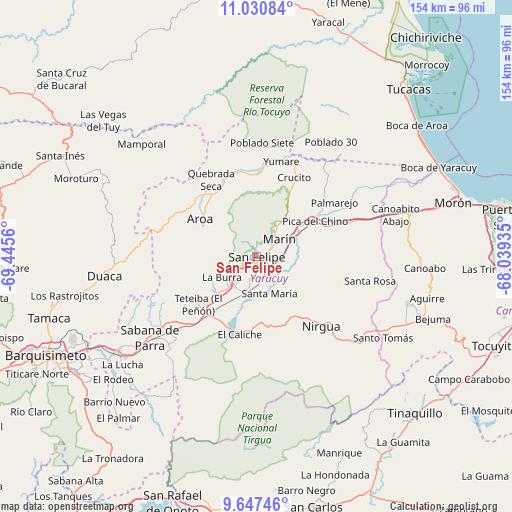
San Felipe GPS coordinates[2]
10° 20' 23.676" North, 68° 44' 32.892" West
| Map corner | latitude | longitude |
|---|---|---|
| Upper-left | 11.03084°, | -69.4456° |
| Center: | 10.33991°, | -68.74247° |
| Lower-right: | 9.64746°, | -68.03935° |
| Map W x H: | 153.8×153.8 km | = 95.6×95.6mi |
| max Lat: | 11.94788° ⇑23.9% North |
| San Felipe: | 10.33991° |
| min Lat: | ⇓76.1% South 1.92027° |
| min Long | San Felipe | max Long |
| -72.55212° | -68.74247° | -60.99778° |
| W 51.1%⇐ | ⇒48.9% E |
Elevation
Elevation of San Felipe is 287 m = 942 ft, and this is 93.6 m = 307 ft below average elevation for this country.
| Max E: |
2986 m = 9797 ft | 36.9% |
| Avg. | 380.6 m = 1249 ft | |
| San Felipe | 287 m = 942 ft | |
Min E: |
-4 m = -13 ft | 63.1% |
See also: San Felipe elevation on elevation.city.
Geographical zone
San Felipe is located in North Torrid zone (between Equator and Tropic of Cancer). Distance of Equator is 1149.7 km =714.4 mi to South.| Distance of | km | miles | from San Felipe |
|---|---|---|---|
| North Pole | 8857.4 | 5503.7 | to North |
| Arctic Circle | 6251.5 | 3884.5 | to North |
| Tropic Cancer | 1456.2 | 904.8 | to North |
| Equator | 1149.7 | 714.4 | to South |


Nearby cities:
15 places around San Felipe: (largest is in red/bold)
• Aroa
20 km =12.4 mi,  303°
303°
• Boraure
10.7 km =6.6 mi,  196°
196°
• Chivacoa
26.1 km =16.2 mi,  219°
219°
• Cocorote
5 km =3.1 mi,  242°
242°
• Duaca
46.3 km =28.8 mi,  262°
262°
• Farriar
24.8 km =15.4 mi,  54°
54°
• Guama
11.8 km =7.3 mi,  225°
225°
• Independencia
1.5 km =0.9 mi,  245°
245°
• Miranda
43.6 km =27.1 mi,  118°
118°
• Nirgua
28.7 km =17.8 mi,  137°
137°
• Palmasola
35.6 km =22.1 mi,  37°
37°
• Sabana de Parra
40.3 km =25 mi, 232°
• San Pablo
15 km =9.3 mi, 227°
• Urachiche
35.4 km =22 mi, 235°
• Yumare
29.6 km =18.4 mi,  14°
14°
Sources, notices
• [Note1] Compared only with cities in Venezuela existing in our database
• [Src1] Map data: © OpenStreetMap contributors (CC-BY-SA)
• [Src2] Other city data from geonames.org with taken over terms of usage.
• [Src3] Geographical zone / Annual Mean Temperature by Robert A. Rohde @ Wikipedia
