Ocumare de la Costa geodata
Ocumare de la Costa (Aragua) is a seat of a second-order administrative division; located in Venezuela in America/Caracas (GMT-4) time zone. In our database, there are 108 cities with bigger population. Compared to other cities in Venezuela, 79.9% of cities are located further ↓South; 60.6% of cities are located further ←West and 89.6% of cities have higher elevation than Ocumare de la Costa. Note1


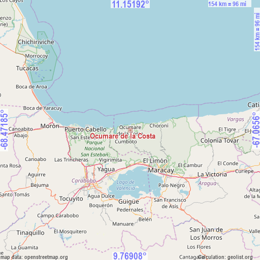
Ocumare de la Costa GPS coordinates[2]
10° 27' 40.572" North, 67° 46' 7.392" West
| Map corner | latitude | longitude |
|---|---|---|
| Upper-left | 11.15192°, | -68.47185° |
| Center: | 10.46127°, | -67.76872° |
| Lower-right: | 9.76908°, | -67.0656° |
| Map W x H: | 153.8×153.8 km | = 95.6×95.6mi |
| max Lat: | 11.94788° ⇑20.1% North |
| Ocumare de la Costa: | 10.46127° |
| min Lat: | ⇓79.9% South 1.92027° |
| min Long | Ocumare de la C | max Long |
| -72.55212° | -67.76872° | -60.99778° |
| W 60.6%⇐ | ⇒39.4% E |
Elevation
Elevation of Ocumare de la Costa is 15 m = 49 ft, and this is 365.6 m = 1199 ft below average elevation for this country.
| Max E: |
2986 m = 9797 ft | 89.6% |
| Avg. | 380.6 m = 1249 ft | |
| Ocumare de la Costa | 15 m = 49 ft | |
Min E: |
-4 m = -13 ft | 10.4% |
See also: Venezuela elevation on elevation.city.
Geographical zone
Ocumare de la Costa is located in North Torrid zone (between Equator and Tropic of Cancer). Distance of Equator is 1163.2 km =722.8 mi to South.| Distance of | km | miles | from Ocumare de la Costa |
|---|---|---|---|
| North Pole | 8843.9 | 5495.3 | to North |
| Arctic Circle | 6238 | 3876.1 | to North |
| Tropic Cancer | 1442.7 | 896.5 | to North |
| Equator | 1163.2 | 722.8 | to South |


Nearby cities:
15 places around Ocumare de la Costa: (largest is in red/bold)
• El Limón
22.8 km =14.2 mi,  139°
139°
• Guacara
28.7 km =17.8 mi,  204°
204°
• Güigüe
42 km =26.1 mi,  181°
181°
• Los Guayos
35.5 km =22.1 mi,  211°
211°
• Maracay
31.8 km =19.8 mi, 142°
• Mariara
19.3 km =12 mi,  163°
163°
• Naguanagua
35.4 km =22 mi,  229°
229°
• Palo Negro
40.5 km =25.2 mi, 142°
• Puerto Cabello
26.7 km =16.6 mi,  272°
272°
• San Diego
30.1 km =18.7 mi,  222°
222°
• San Joaquín
22.5 km =14 mi,  186°
186°
• Santa Cruz
42 km =26.1 mi, 138°
• Santa Rita
36.5 km =22.7 mi, 141°
• Turmero
41.3 km =25.7 mi,  128°
128°
• Valencia
42.3 km =26.3 mi, 218°
Sources, notices
• [Note1] Compared only with cities in Venezuela existing in our database
• [Src1] Map data: © OpenStreetMap contributors (CC-BY-SA)
• [Src2] Other city data from geonames.org with taken over terms of usage.
• [Src3] Geographical zone / Annual Mean Temperature by Robert A. Rohde @ Wikipedia
