Maturín geodata
Maturín (Monagas) is a seat of a first-order administrative division; located in Venezuela in America/Caracas (GMT-4) time zone. With population of 410,972 people, there are 7 cities with bigger population in this country. Compared to other cities in Venezuela, 53.2% of cities are located further ↓South; 94.4% of cities are located further ←West and 73.8% of cities have higher elevation than Maturín. Note1


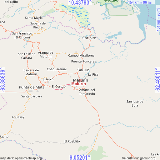
Maturín GPS coordinates[2]
9° 44' 44.484" North, 63° 10' 59.628" West
| Map corner | latitude | longitude |
|---|---|---|
| Upper-left | 10.43793°, | -63.88636° |
| Center: | 9.74569°, | -63.18323° |
| Lower-right: | 9.05201°, | -62.48011° |
| Map W x H: | 154.1×154.1 km | = 95.8×95.8mi |
| max Lat: | 11.94788° ⇑46.8% North |
| Maturín: | 9.74569° |
| min Lat: | ⇓53.2% South 1.92027° |
| min Long | Maturín | max Long |
| -72.55212° | -63.18323° | -60.99778° |
| W 94.4%⇐ | ⇒5.6% E |
Elevation
Elevation of Maturín is 71 m = 233 ft, and this is 309.6 m = 1016 ft below average elevation for this country.
| Max E: |
2986 m = 9797 ft | 73.8% |
| Avg. | 380.6 m = 1249 ft | |
| Maturín | 71 m = 233 ft | |
Min E: |
-4 m = -13 ft | 26.2% |
See also: Maturín elevation on elevation.city.
Geographical zone
Maturín is located in North Torrid zone (between Equator and Tropic of Cancer). Distance of Equator is 1083.6 km =673.3 mi to South.| Distance of | km | miles | from Maturín |
|---|---|---|---|
| North Pole | 8923.4 | 5544.7 | to North |
| Arctic Circle | 6317.6 | 3925.6 | to North |
| Tropic Cancer | 1522.3 | 945.9 | to North |
| Equator | 1083.6 | 673.3 | to South |


Nearby cities:
15 places around Maturín: (largest is in red/bold)
• Aguasay
69.8 km =43.4 mi,  239°
239°
• Aragua
41.6 km =25.8 mi,  306°
306°
• Caicara
47.8 km =29.7 mi,  279°
279°
• Cariaco
92.8 km =57.7 mi,  334°
334°
• Caripe
58.9 km =36.6 mi,  323°
323°
• Caripito
41.7 km =25.9 mi,  12°
12°
• Casanay
88.1 km =54.7 mi,  343°
343°
• Cumanacoa
98.2 km =61 mi,  304°
304°
• El Pilar
89.2 km =55.4 mi,  2°
2°
• Punta de Mata
47.1 km =29.3 mi,  262°
262°
• Quiriquire
26.3 km =16.3 mi,  351°
351°
• San Antonio
72.5 km =45 mi, 304°
• San José de Aerocuar
96.3 km =59.8 mi, 350°
• Santa Bárbara
49.2 km =30.6 mi,  251°
251°
• Tunapuy
92.6 km =57.5 mi, 5°
Sources, notices
• [Note1] Compared only with cities in Venezuela existing in our database
• [Src1] Map data: © OpenStreetMap contributors (CC-BY-SA)
• [Src2] Other city data from geonames.org with taken over terms of usage.
• [Src3] Geographical zone / Annual Mean Temperature by Robert A. Rohde @ Wikipedia
