Cumanacoa geodata
Cumanacoa (Sucre) is a seat of a second-order administrative division; located in Venezuela in America/Caracas (GMT-4) time zone. In our database, there are 108 cities with bigger population. Compared to other cities in Venezuela, 71.5% of cities are located further ↓South; 88.5% of cities are located further ←West and 58.5% of cities have lower elevation than Cumanacoa. Note1


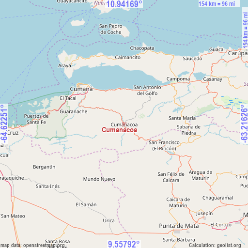
Cumanacoa GPS coordinates[2]
10° 15' 2.016" North, 63° 55' 9.768" West
| Map corner | latitude | longitude |
|---|---|---|
| Upper-left | 10.94169°, | -64.62251° |
| Center: | 10.25056°, | -63.91938° |
| Lower-right: | 9.55792°, | -63.21626° |
| Map W x H: | 153.9×153.9 km | = 95.6×95.6mi |
| max Lat: | 11.94788° ⇑28.5% North |
| Cumanacoa: | 10.25056° |
| min Lat: | ⇓71.5% South 1.92027° |
| min Long | Cumanacoa | max Long |
| -72.55212° | -63.91938° | -60.99778° |
| W 88.5%⇐ | ⇒11.5% E |
Elevation
Elevation of Cumanacoa is 230 m = 755 ft, and this is 150.6 m = 494 ft below average elevation for this country.
| Max E: |
2986 m = 9797 ft | 41.5% |
| Avg. | 380.6 m = 1249 ft | |
| Cumanacoa | 230 m = 755 ft | |
Min E: |
-4 m = -13 ft | 58.5% |
See also: Venezuela elevation on elevation.city.
Geographical zone
Cumanacoa is located in North Torrid zone (between Equator and Tropic of Cancer). Distance of Equator is 1139.8 km =708.2 mi to South.| Distance of | km | miles | from Cumanacoa |
|---|---|---|---|
| North Pole | 8867.3 | 5509.9 | to North |
| Arctic Circle | 6261.4 | 3890.7 | to North |
| Tropic Cancer | 1466.2 | 911.1 | to North |
| Equator | 1139.8 | 708.2 | to South |


Nearby cities:
15 places around Cumanacoa: (largest is in red/bold)
• Aragua
56.6 km =35.2 mi,  123°
123°
• Araya
51.9 km =32.2 mi,  314°
314°
• Caicara
58.7 km =36.5 mi,  145°
145°
• Cariaco
48.5 km =30.1 mi,  55°
55°
• Caripe
46.6 km =29 mi,  100°
100°
• Casanay
61.7 km =38.3 mi, 62°
• Cumaná
36.6 km =22.7 mi, 308°
• Guanta
74.2 km =46.1 mi,  268°
268°
• Marigüitar
22 km =13.7 mi,  5°
5°
• Punta de Mata
70.9 km =44.1 mi, 151°
• Punta de Piedras
74.9 km =46.5 mi,  344°
344°
• San Antonio
25.8 km =16 mi, 124°
• San Antonio del Golfo
25.6 km =15.9 mi,  33°
33°
• San José de Aerocuar
75.4 km =46.9 mi, 58°
• San Pedro de Coche
59.6 km =37 mi,  351°
351°
Sources, notices
• [Note1] Compared only with cities in Venezuela existing in our database
• [Src1] Map data: © OpenStreetMap contributors (CC-BY-SA)
• [Src2] Other city data from geonames.org with taken over terms of usage.
• [Src3] Geographical zone / Annual Mean Temperature by Robert A. Rohde @ Wikipedia
