Tunapuy geodata
Tunapuy (Sucre) is a seat of a second-order administrative division; located in Venezuela in America/Caracas (GMT-4) time zone. In our database, there are 108 cities with bigger population. Compared to other cities in Venezuela, 85.8% of cities are located further ↓South; 95.2% of cities are located further ←West and 80.7% of cities have higher elevation than Tunapuy. Note1


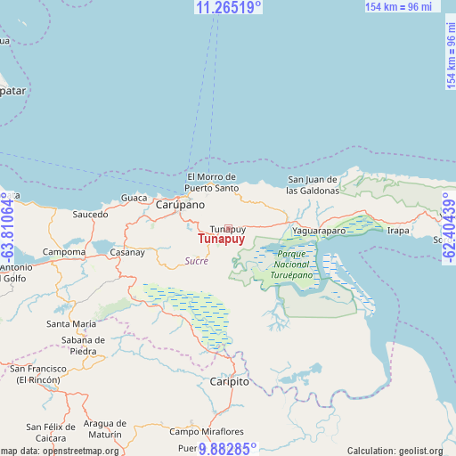
Tunapuy GPS coordinates[2]
10° 34' 29.28" North, 63° 6' 27.036" West
| Map corner | latitude | longitude |
|---|---|---|
| Upper-left | 11.26519°, | -63.81064° |
| Center: | 10.5748°, | -63.10751° |
| Lower-right: | 9.88285°, | -62.40439° |
| Map W x H: | 153.7×153.7 km | = 95.5×95.5mi |
| max Lat: | 11.94788° ⇑14.2% North |
| Tunapuy: | 10.5748° |
| min Lat: | ⇓85.8% South 1.92027° |
| min Long | Tunapuy | max Long |
| -72.55212° | -63.10751° | -60.99778° |
| W 95.2%⇐ | ⇒4.8% E |
Elevation
Elevation of Tunapuy is 48 m = 157 ft, and this is 332.6 m = 1091 ft below average elevation for this country.
| Max E: |
2986 m = 9797 ft | 80.7% |
| Avg. | 380.6 m = 1249 ft | |
| Tunapuy | 48 m = 157 ft | |
Min E: |
-4 m = -13 ft | 19.3% |
See also: Venezuela elevation on elevation.city.
Geographical zone
Tunapuy is located in North Torrid zone (between Equator and Tropic of Cancer). Distance of Equator is 1175.8 km =730.6 mi to South.| Distance of | km | miles | from Tunapuy |
|---|---|---|---|
| North Pole | 8831.3 | 5487.5 | to North |
| Arctic Circle | 6225.4 | 3868.3 | to North |
| Tropic Cancer | 1430.1 | 888.6 | to North |
| Equator | 1175.8 | 730.6 | to South |


Nearby cities:
15 places around Tunapuy: (largest is in red/bold)
• Aragua
79 km =49.1 mi,  211°
211°
• Cariaco
49.4 km =30.7 mi,  259°
259°
• Caripe
62 km =38.5 mi,  223°
223°
• Caripito
51.5 km =32 mi,  179°
179°
• Carúpano
18.9 km =11.7 mi,  302°
302°
• Casanay
34.8 km =21.6 mi, 256°
• El Pilar
5.9 km =3.7 mi,  239°
239°
• Irapa
57.4 km =35.7 mi,  90°
90°
• Marigüitar
88 km =54.7 mi, 260°
• Quiriquire
67.3 km =41.8 mi,  190°
190°
• Río Caribe
13.7 km =8.5 mi,  359°
359°
• San Antonio
84.5 km =52.5 mi,  233°
233°
• San Antonio del Golfo
75.9 km =47.2 mi, 258°
• San José de Aerocuar
24.3 km =15.1 mi,  276°
276°
• Yaguaraparo
30.7 km =19.1 mi, 91°
Sources, notices
• [Note1] Compared only with cities in Venezuela existing in our database
• [Src1] Map data: © OpenStreetMap contributors (CC-BY-SA)
• [Src2] Other city data from geonames.org with taken over terms of usage.
• [Src3] Geographical zone / Annual Mean Temperature by Robert A. Rohde @ Wikipedia
