Phú Mỹ geodata
Phú Mỹ (An Giang) is a seat of a second-order administrative division; located in Vietnam in Asia/Ho_Chi_Minh (GMT+7) time zone. In our database, there are 94 cities with bigger population. Compared to other cities in Vietnam, 82.4% of cities are located further ↑North; 81.4% of cities are located further →East and 61.7% of cities have higher elevation than Phú Mỹ. Note1


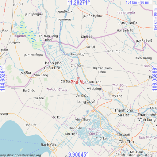
Phú Mỹ GPS coordinates[2]
10° 35' 32.496" North, 105° 21' 20.628" East
| Map corner | latitude | longitude |
|---|---|---|
| Upper-left | 11.28271°, | 104.65261° |
| Center: | 10.59236°, | 105.35573° |
| Lower-right: | 9.90045°, | 106.05886° |
| Map W x H: | 153.7×153.7 km | = 95.5×95.5mi |
| max Lat: | 23.27841° ⇑82.4% North |
| Phú Mỹ: | 10.59236° |
| min Lat: | ⇓17.6% South 8.65724° |
| min Long | Phú Mỹ | max Long |
| 102.4579° | 105.35573° | 112.72541° |
| W 18.6%⇐ | ⇒81.4% E |
Elevation
Elevation of Phú Mỹ is 10 m = 33 ft, and this is 119.5 m = 392 ft below average elevation for this country.
| Max E: |
1592 m = 5223 ft | 61.7% |
| Avg. | 129.5 m = 425 ft | |
| Phú Mỹ | 10 m = 33 ft | |
Min E: |
-1 m = -3 ft | 38.3% |
See also: Vietnam elevation on elevation.city.
Geographical zone
Phú Mỹ is located in North Torrid zone (between Equator and Tropic of Cancer). Distance of Equator is 1177.8 km =731.9 mi to South.| Distance of | km | miles | from Phú Mỹ |
|---|---|---|---|
| North Pole | 8829.3 | 5486.3 | to North |
| Arctic Circle | 6223.4 | 3867 | to North |
| Tropic Cancer | 1428.2 | 887.4 | to North |
| Equator | 1177.8 | 731.9 | to South |


Nearby cities:
15 places around Phú Mỹ: (largest is in red/bold)
• An Châu
16.7 km =10.4 mi,  168°
168°
• An Phú
38.2 km =23.7 mi,  310°
310°
• Cao Lãnh
33.7 km =20.9 mi,  115°
115°
• Cho Dok
28.7 km =17.8 mi,  294°
294°
• Chợ Mới
7 km =4.3 mi,  130°
130°
• Cái Dầu
12.8 km =8 mi,  260°
260°
• Long Xuyên
24.5 km =15.2 mi,  159°
159°
• Lấp Vò
31.3 km =19.4 mi,  145°
145°
• Nhà Bàng
38.1 km =23.7 mi,  275°
275°
• Núi Sập
37.7 km =23.4 mi,  194°
194°
• Sa Rài
33.1 km =20.6 mi,  21°
21°
• Thanh Bình
14.4 km =8.9 mi,  103°
103°
• Thốt Nốt
40.6 km =25.2 mi, 151°
• Tràm Chim
24.4 km =15.2 mi,  69°
69°
• Tân Châu
26.2 km =16.3 mi,  330°
330°
Sources, notices
• [Note1] Compared only with cities in Vietnam existing in our database
• [Src1] Map data: © OpenStreetMap contributors (CC-BY-SA)
• [Src2] Other city data from geonames.org with taken over terms of usage.
• [Src3] Geographical zone / Annual Mean Temperature by Robert A. Rohde @ Wikipedia
