Chợ Mới geodata
Chợ Mới (An Giang) is a seat of a second-order administrative division; located in Vietnam in Asia/Ho_Chi_Minh (GMT+7) time zone. In our database, there are 94 cities with bigger population. Compared to other cities in Vietnam, 83% of cities are located further ↑North; 79.9% of cities are located further →East and 71.9% of cities have higher elevation than Chợ Mới. Note1


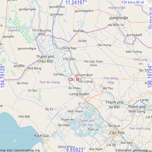
Chợ Mới GPS coordinates[2]
10° 33' 4.428" North, 105° 24' 15.876" East
| Map corner | latitude | longitude |
|---|---|---|
| Upper-left | 11.24167°, | 104.70129° |
| Center: | 10.55123°, | 105.40441° |
| Lower-right: | 9.85923°, | 106.10754° |
| Map W x H: | 153.7×153.7 km | = 95.5×95.5mi |
| max Lat: | 23.27841° ⇑83% North |
| Chợ Mới: | 10.55123° |
| min Lat: | ⇓17% South 8.65724° |
| min Long | Chợ Mới | max Long |
| 102.4579° | 105.40441° | 112.72541° |
| W 20.1%⇐ | ⇒79.9% E |
Elevation
Elevation of Chợ Mới is 8 m = 26 ft, and this is 121.5 m = 399 ft below average elevation for this country.
| Max E: |
1592 m = 5223 ft | 71.9% |
| Avg. | 129.5 m = 425 ft | |
| Chợ Mới | 8 m = 26 ft | |
Min E: |
-1 m = -3 ft | 28.1% |
See also: Vietnam elevation on elevation.city.
Geographical zone
Chợ Mới is located in North Torrid zone (between Equator and Tropic of Cancer). Distance of Equator is 1173.2 km =729 mi to South.| Distance of | km | miles | from Chợ Mới |
|---|---|---|---|
| North Pole | 8833.9 | 5489.1 | to North |
| Arctic Circle | 6228 | 3869.9 | to North |
| Tropic Cancer | 1432.7 | 890.2 | to North |
| Equator | 1173.2 | 729 | to South |


Nearby cities:
15 places around Chợ Mới: (largest is in red/bold)
• An Châu
11.9 km =7.4 mi,  189°
189°
• Cao Lãnh
27 km =16.8 mi,  112°
112°
• Cho Dok
35.5 km =22.1 mi,  297°
297°
• Cái Dầu
18.1 km =11.2 mi,  278°
278°
• Long Xuyên
18.6 km =11.6 mi,  169°
169°
• Lấp Vò
24.5 km =15.2 mi,  149°
149°
• Mỹ Thọ
34 km =21.1 mi, 110°
• Núi Sập
35.2 km =21.9 mi,  205°
205°
• Phú Mỹ
7 km =4.3 mi,  310°
310°
• Sa Rài
36.1 km =22.4 mi,  10°
10°
• Thanh Bình
8.8 km =5.5 mi,  82°
82°
• Thốt Nốt
34.1 km =21.2 mi,  155°
155°
• Tràm Chim
21.9 km =13.6 mi,  52°
52°
• Tân Châu
32.9 km =20.4 mi,  326°
326°
• Vĩnh Thạnh
36.5 km =22.7 mi,  181°
181°
Sources, notices
• [Note1] Compared only with cities in Vietnam existing in our database
• [Src1] Map data: © OpenStreetMap contributors (CC-BY-SA)
• [Src2] Other city data from geonames.org with taken over terms of usage.
• [Src3] Geographical zone / Annual Mean Temperature by Robert A. Rohde @ Wikipedia
