Tràm Chim geodata
Tràm Chim (Đồng Tháp) is a seat of a second-order administrative division; located in Vietnam in Asia/Ho_Chi_Minh (GMT+7) time zone. In our database, there are 94 cities with bigger population. Compared to other cities in Vietnam, 80.9% of cities are located further ↑North; 74.6% of cities are located further →East and 80.8% of cities have higher elevation than Tràm Chim. Note1


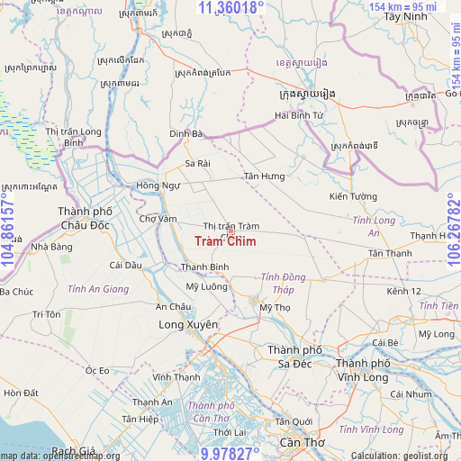
Tràm Chim GPS coordinates[2]
10° 40' 12.036" North, 105° 33' 52.884" East
| Map corner | latitude | longitude |
|---|---|---|
| Upper-left | 11.36018°, | 104.86157° |
| Center: | 10.67001°, | 105.56469° |
| Lower-right: | 9.97827°, | 106.26782° |
| Map W x H: | 153.7×153.7 km | = 95.5×95.5mi |
| max Lat: | 23.27841° ⇑80.9% North |
| Tràm Chim: | 10.67001° |
| min Lat: | ⇓19.1% South 8.65724° |
| min Long | Tràm Chim | max Long |
| 102.4579° | 105.56469° | 112.72541° |
| W 25.4%⇐ | ⇒74.6% E |
Elevation
Elevation of Tràm Chim is 6 m = 20 ft, and this is 123.5 m = 405 ft below average elevation for this country.
| Max E: |
1592 m = 5223 ft | 80.8% |
| Avg. | 129.5 m = 425 ft | |
| Tràm Chim | 6 m = 20 ft | |
Min E: |
-1 m = -3 ft | 19.2% |
See also: Vietnam elevation on elevation.city.
Geographical zone
Tràm Chim is located in North Torrid zone (between Equator and Tropic of Cancer). Distance of Equator is 1186.4 km =737.2 mi to South.| Distance of | km | miles | from Tràm Chim |
|---|---|---|---|
| North Pole | 8820.7 | 5480.9 | to North |
| Arctic Circle | 6214.8 | 3861.7 | to North |
| Tropic Cancer | 1419.5 | 882 | to North |
| Equator | 1186.4 | 737.2 | to South |


Nearby cities:
15 places around Tràm Chim: (largest is in red/bold)
• An Châu
31.7 km =19.7 mi,  218°
218°
• Cao Lãnh
24.5 km =15.2 mi,  162°
162°
• Chợ Mới
21.9 km =13.6 mi,  232°
232°
• Cái Dầu
37 km =23 mi,  253°
253°
• Lai Vung
43.9 km =27.3 mi,  166°
166°
• Long Xuyên
34.6 km =21.5 mi,  204°
204°
• Lấp Vò
34.6 km =21.5 mi,  188°
188°
• Mỹ Thọ
29 km =18 mi,  150°
150°
• Phú Mỹ
24.4 km =15.2 mi, 249°
• Sa Rài
24.7 km =15.3 mi,  334°
334°
• Thanh Bình
14.9 km =9.3 mi, 216°
• Thốt Nốt
44.4 km =27.6 mi,  184°
184°
• Tân Châu
38.3 km =23.8 mi,  291°
291°
• Tân Hưng
21.1 km =13.1 mi,  29°
29°
• Vĩnh Hưng
34.4 km =21.4 mi,  44°
44°
Sources, notices
• [Note1] Compared only with cities in Vietnam existing in our database
• [Src1] Map data: © OpenStreetMap contributors (CC-BY-SA)
• [Src2] Other city data from geonames.org with taken over terms of usage.
• [Src3] Geographical zone / Annual Mean Temperature by Robert A. Rohde @ Wikipedia
