Cho Dok geodata
Cho Dok (An Giang) is a populated place; located in Vietnam in Asia/Ho_Chi_Minh (GMT+7) time zone. With population of 70,239 people, there are 44 cities with bigger population in this country. Compared to other cities in Vietnam, 80.4% of cities are located further ↑North; 87.3% of cities are located further →East and 61.7% of cities have higher elevation than Cho Dok. Note1


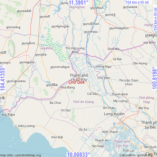
Cho Dok GPS coordinates[2]
10° 42' 0" North, 105° 7' 0.012" East
| Map corner | latitude | longitude |
|---|---|---|
| Upper-left | 11.3901°, | 104.41355° |
| Center: | 10.7°, | 105.11667° |
| Lower-right: | 10.00833°, | 105.8198° |
| Map W x H: | 153.6×153.6 km | = 95.4×95.4mi |
| max Lat: | 23.27841° ⇑80.4% North |
| Cho Dok: | 10.7° |
| min Lat: | ⇓19.6% South 8.65724° |
| min Long | Cho Dok | max Long |
| 102.4579° | 105.11667° | 112.72541° |
| W 12.7%⇐ | ⇒87.3% E |
Elevation
Elevation of Cho Dok is 10 m = 33 ft, and this is 119.5 m = 392 ft below average elevation for this country.
| Max E: |
1592 m = 5223 ft | 61.7% |
| Avg. | 129.5 m = 425 ft | |
| Cho Dok | 10 m = 33 ft | |
Min E: |
-1 m = -3 ft | 38.3% |
See also: Cho Dok elevation on elevation.city.
Geographical zone
Cho Dok is located in North Torrid zone (between Equator and Tropic of Cancer). Distance of Equator is 1189.7 km =739.2 mi to South.| Distance of | km | miles | from Cho Dok |
|---|---|---|---|
| North Pole | 8817.3 | 5478.8 | to North |
| Arctic Circle | 6211.4 | 3859.6 | to North |
| Tropic Cancer | 1416.2 | 880 | to North |
| Equator | 1189.7 | 739.2 | to South |


Nearby cities:
15 places around Cho Dok: (largest is in red/bold)
• An Châu
40.8 km =25.4 mi,  133°
133°
• An Phú
13.2 km =8.2 mi,  347°
347°
• Chợ Mới
35.5 km =22.1 mi,  117°
117°
• Cái Dầu
19.4 km =12.1 mi,  136°
136°
• Long Xuyên
49.3 km =30.6 mi, 135°
• Lấp Vò
57.9 km =36 mi, 130°
• Ngoc Hon Doc
60.8 km =37.8 mi,  199°
199°
• Nhà Bàng
14.5 km =9 mi,  234°
234°
• Núi Sập
51.1 km =31.8 mi,  161°
161°
• Phú Mỹ
28.7 km =17.8 mi,  114°
114°
• Sa Rài
42.6 km =26.5 mi,  63°
63°
• Thanh Bình
43 km =26.7 mi, 110°
• Tri Tôn
33.6 km =20.9 mi, 202°
• Tràm Chim
49.1 km =30.5 mi,  93°
93°
• Tân Châu
17.3 km =10.7 mi,  50°
50°
Sources, notices
• [Note1] Compared only with cities in Vietnam existing in our database
• [Src1] Map data: © OpenStreetMap contributors (CC-BY-SA)
• [Src2] Other city data from geonames.org with taken over terms of usage.
• [Src3] Geographical zone / Annual Mean Temperature by Robert A. Rohde @ Wikipedia
