Đông Hưng geodata
Đông Hưng (Thái Bình) is a seat of a second-order administrative division; located in Vietnam in Asia/Ho_Chi_Minh (GMT+7) time zone. In our database, there are 94 cities with bigger population. Compared to other cities in Vietnam, 65.4% of cities are located further ↓South; 58.4% of cities are located further ←West and 87.1% of cities have higher elevation than Đông Hưng. Note1


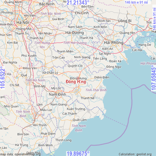
Đông Hưng GPS coordinates[2]
20° 33' 23.436" North, 106° 21' 19.152" East
| Map corner | latitude | longitude |
|---|---|---|
| Upper-left | 21.21343°, | 105.6522° |
| Center: | 20.55651°, | 106.35532° |
| Lower-right: | 19.89675°, | 107.05845° |
| Map W x H: | 146.4×146.4 km | = 91×91mi |
| max Lat: | 23.27841° ⇑34.6% North |
| Đông Hưng: | 20.55651° |
| min Lat: | ⇓65.4% South 8.65724° |
| min Long | Đông Hưng | max Long |
| 102.4579° | 106.35532° | 112.72541° |
| W 58.4%⇐ | ⇒41.6% E |
Elevation
Elevation of Đông Hưng is 5 m = 16 ft, and this is 124.5 m = 408 ft below average elevation for this country.
| Max E: |
1592 m = 5223 ft | 87.1% |
| Avg. | 129.5 m = 425 ft | |
| Đông Hưng | 5 m = 16 ft | |
Min E: |
-1 m = -3 ft | 12.9% |
See also: Vietnam elevation on elevation.city.
Geographical zone
Đông Hưng is located in North Torrid zone (between Equator and Tropic of Cancer). Distance of this Northern Tropic circle is 320.2 km =199 mi to North.| Distance of | km | miles | from Đông Hưng |
|---|---|---|---|
| North Pole | 7721.4 | 4797.9 | to North |
| Arctic Circle | 5115.5 | 3178.6 | to North |
| Tropic Cancer | 320.2 | 199 | to North |
| Equator | 2285.7 | 1420.3 | to South |


Nearby cities:
15 places around Đông Hưng: (largest is in red/bold)
• Cổ Lễ
27.5 km =17.1 mi,  199°
199°
• Giemdiem
22.2 km =13.8 mi,  89°
89°
• Hưng Hà
14.1 km =8.8 mi,  285°
285°
• Mỹ Lộc
29.3 km =18.2 mi,  244°
244°
• Nam Định
23 km =14.3 mi,  233°
233°
• Ninh Giang
19.9 km =12.4 mi,  12°
12°
• Quỳnh Côi
12.1 km =7.5 mi,  346°
346°
• Thanh Miện
28 km =17.4 mi,  336°
336°
• Thanh Nê
20.6 km =12.8 mi,  155°
155°
• Thái Bình
11.9 km =7.4 mi,  187°
187°
• Tiên Lãng
27.9 km =17.3 mi,  47°
47°
• Tiền Hải
22.8 km =14.2 mi,  137°
137°
• Trần Cao
26.5 km =16.5 mi,  316°
316°
• Vũ Thư
14.9 km =9.3 mi,  206°
206°
• Xuân Trường
29.5 km =18.3 mi,  184°
184°
Sources, notices
• [Note1] Compared only with cities in Vietnam existing in our database
• [Src1] Map data: © OpenStreetMap contributors (CC-BY-SA)
• [Src2] Other city data from geonames.org with taken over terms of usage.
• [Src3] Geographical zone / Annual Mean Temperature by Robert A. Rohde @ Wikipedia
