Thanh Nê geodata
Thanh Nê (Thái Bình) is a seat of a second-order administrative division; located in Vietnam in Asia/Ho_Chi_Minh (GMT+7) time zone. In our database, there are 94 cities with bigger population. Compared to other cities in Vietnam, 63.3% of cities are located further ↓South; 61% of cities are located further ←West and 95.4% of cities have higher elevation than Thanh Nê. Note1


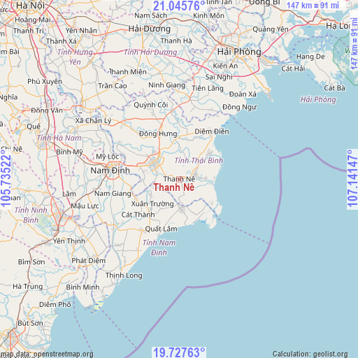
Thanh Nê GPS coordinates[2]
20° 23' 17.16" North, 106° 26' 18.024" East
| Map corner | latitude | longitude |
|---|---|---|
| Upper-left | 21.04576°, | 105.73522° |
| Center: | 20.3881°, | 106.43834° |
| Lower-right: | 19.72763°, | 107.14147° |
| Map W x H: | 146.6×146.6 km | = 91.1×91.1mi |
| max Lat: | 23.27841° ⇑36.7% North |
| Thanh Nê: | 20.3881° |
| min Lat: | ⇓63.3% South 8.65724° |
| min Long | Thanh Nê | max Long |
| 102.4579° | 106.43834° | 112.72541° |
| W 61%⇐ | ⇒39% E |
Elevation
Elevation of Thanh Nê is 3 m = 10 ft, and this is 126.5 m = 415 ft below average elevation for this country.
| Max E: |
1592 m = 5223 ft | 95.4% |
| Avg. | 129.5 m = 425 ft | |
| Thanh Nê | 3 m = 10 ft | |
Min E: |
-1 m = -3 ft | 4.6% |
See also: Vietnam elevation on elevation.city.
Geographical zone
Thanh Nê is located in North Torrid zone (between Equator and Tropic of Cancer). Distance of this Northern Tropic circle is 339 km =210.6 mi to North.| Distance of | km | miles | from Thanh Nê |
|---|---|---|---|
| North Pole | 7740.1 | 4809.5 | to North |
| Arctic Circle | 5134.2 | 3190.2 | to North |
| Tropic Cancer | 339 | 210.6 | to North |
| Equator | 2266.9 | 1408.6 | to South |


Nearby cities:
15 places around Thanh Nê: (largest is in red/bold)
• Cổ Lễ
19.4 km =12.1 mi,  248°
248°
• Giemdiem
23.3 km =14.5 mi,  35°
35°
• Hưng Hà
31.7 km =19.7 mi,  315°
315°
• Lien De
32.1 km =19.9 mi,  234°
234°
• Mỹ Lộc
35.5 km =22.1 mi,  279°
279°
• Nam Giang
27.9 km =17.3 mi,  257°
257°
• Nam Định
27.7 km =17.2 mi, 280°
• Ngô Đồng
11.7 km =7.3 mi,  177°
177°
• Quỳnh Côi
32.6 km =20.3 mi,  339°
339°
• Thái Bình
12.3 km =7.6 mi,  303°
303°
• Tiền Hải
7.1 km =4.4 mi,  74°
74°
• Vũ Thư
16.3 km =10.1 mi,  289°
289°
• Xuân Trường
15.3 km =9.5 mi, 225°
• Yên Định
25.5 km =15.8 mi,  215°
215°
• Đông Hưng
20.6 km =12.8 mi, 335°
Sources, notices
• [Note1] Compared only with cities in Vietnam existing in our database
• [Src1] Map data: © OpenStreetMap contributors (CC-BY-SA)
• [Src2] Other city data from geonames.org with taken over terms of usage.
• [Src3] Geographical zone / Annual Mean Temperature by Robert A. Rohde @ Wikipedia
