Hưng Hà geodata
Hưng Hà (Thái Bình) is a seat of a second-order administrative division; located in Vietnam in Asia/Ho_Chi_Minh (GMT+7) time zone. In our database, there are 94 cities with bigger population. Compared to other cities in Vietnam, 66.1% of cities are located further ↓South; 54% of cities are located further ←West and 92.5% of cities have higher elevation than Hưng Hà. Note1


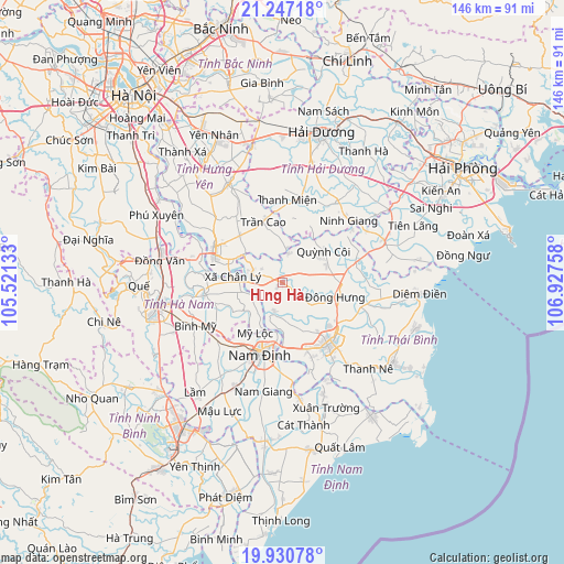
Hưng Hà GPS coordinates[2]
20° 35' 25.44" North, 106° 13' 28.02" East
| Map corner | latitude | longitude |
|---|---|---|
| Upper-left | 21.24718°, | 105.52133° |
| Center: | 20.5904°, | 106.22445° |
| Lower-right: | 19.93078°, | 106.92758° |
| Map W x H: | 146.4×146.4 km | = 91×91mi |
| max Lat: | 23.27841° ⇑33.9% North |
| Hưng Hà: | 20.5904° |
| min Lat: | ⇓66.1% South 8.65724° |
| min Long | Hưng Hà | max Long |
| 102.4579° | 106.22445° | 112.72541° |
| W 54%⇐ | ⇒46% E |
Elevation
Elevation of Hưng Hà is 4 m = 13 ft, and this is 125.5 m = 412 ft below average elevation for this country.
| Max E: |
1592 m = 5223 ft | 92.5% |
| Avg. | 129.5 m = 425 ft | |
| Hưng Hà | 4 m = 13 ft | |
Min E: |
-1 m = -3 ft | 7.5% |
See also: Vietnam elevation on elevation.city.
Geographical zone
Hưng Hà is located in North Torrid zone (between Equator and Tropic of Cancer). Distance of this Northern Tropic circle is 316.5 km =196.7 mi to North.| Distance of | km | miles | from Hưng Hà |
|---|---|---|---|
| North Pole | 7717.6 | 4795.5 | to North |
| Arctic Circle | 5111.7 | 3176.3 | to North |
| Tropic Cancer | 316.5 | 196.7 | to North |
| Equator | 2289.4 | 1422.6 | to South |


Nearby cities:
15 places around Hưng Hà: (largest is in red/bold)
• Bình Mỹ
24.9 km =15.5 mi,  243°
243°
• Hòa Mạc
25.2 km =15.7 mi,  283°
283°
• Hưng Yên
19.1 km =11.9 mi,  289°
289°
• Lương Bằng
23.9 km =14.9 mi,  314°
314°
• Mỹ Lộc
20.9 km =13 mi,  217°
217°
• Nam Định
18.1 km =11.2 mi,  195°
195°
• Ninh Giang
23.9 km =14.9 mi,  49°
49°
• Quỳnh Côi
13.3 km =8.3 mi, 53°
• Thanh Miện
22 km =13.7 mi,  5°
5°
• Thái Bình
19.7 km =12.2 mi,  142°
142°
• Trần Cao
16.2 km =10.1 mi,  343°
343°
• Vĩnh Trụ
20.7 km =12.9 mi,  260°
260°
• Vũ Thư
18.4 km =11.4 mi,  157°
157°
• Vương
16.6 km =10.3 mi,  317°
317°
• Đông Hưng
14.1 km =8.8 mi,  105°
105°
Sources, notices
• [Note1] Compared only with cities in Vietnam existing in our database
• [Src1] Map data: © OpenStreetMap contributors (CC-BY-SA)
• [Src2] Other city data from geonames.org with taken over terms of usage.
• [Src3] Geographical zone / Annual Mean Temperature by Robert A. Rohde @ Wikipedia
