Ia Kha geodata
Ia Kha (Gia Lai) is a seat of a second-order administrative division; located in Vietnam in Asia/Ho_Chi_Minh (GMT+7) time zone. In our database, there are 94 cities with bigger population. Compared to other cities in Vietnam, 60.7% of cities are located further ↑North; 82.9% of cities are located further ←West and 92.5% of cities have lower elevation than Ia Kha. Note1


Ia Kha GPS coordinates[2]
13° 57' 44.712" North, 107° 50' 41.424" East
| Map corner | latitude | longitude |
|---|---|---|
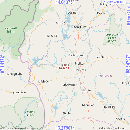
| Upper-left | 14.64375°, | 107.14172° |
| Center: | 13.96242°, | 107.84484° |
| Lower-right: | 13.27907°, | 108.54797° |
| Map W x H: | 151.7×151.7 km | = 94.3×94.3mi |
| max Lat: | 23.27841° ⇑60.7% North |
| Ia Kha: | 13.96242° |
| min Lat: | ⇓39.3% South 8.65724° |
| min Long | Ia Kha | max Long |
| 102.4579° | 107.84484° | 112.72541° |
| W 82.9%⇐ | ⇒17.1% E |
Elevation
Elevation of Ia Kha is 586 m = 1923 ft, and this is 456.5 m = 1498 ft above average elevation for this country.
| Max E: |
1592 m = 5223 ft | 7.5% |
| Ia Kha | 586 m 1923 ft | |
| Avg. | 129.5 m = 425 ft | |
Min E: |
-1 m = -3 ft | 92.5% |
See also: Vietnam elevation on elevation.city.
Geographical zone
Ia Kha is located in North Torrid zone (between Equator and Tropic of Cancer). Distance of this Northern Tropic circle is 1053.4 km =654.6 mi to North.| Distance of | km | miles | from Ia Kha |
|---|---|---|---|
| North Pole | 8454.6 | 5253.4 | to North |
| Arctic Circle | 5848.7 | 3634.2 | to North |
| Tropic Cancer | 1053.4 | 654.6 | to North |
| Equator | 1552.5 | 964.7 | to South |


Nearby cities:
15 places around Ia Kha: (largest is in red/bold)
• Chư Prông
23.3 km =14.5 mi,  168°
168°
• Chư Sê
39.4 km =24.5 mi,  139°
139°
• Chư Ty
23.7 km =14.7 mi,  222°
222°
• Ia Pa
81.4 km =50.6 mi,  125°
125°
• K Bang
83.8 km =52.1 mi,  76°
76°
• Kon Dơng
44.5 km =27.7 mi, 78°
• Kon Tum
47 km =29.2 mi,  21°
21°
• Kông Chro
76.4 km =47.5 mi,  105°
105°
• Phú Hòa
20.3 km =12.6 mi,  41°
41°
• Pleiku
16.9 km =10.5 mi, 82°
• Sa Thầy
50.5 km =31.4 mi,  353°
353°
• Đăk Đoa
29.1 km =18.1 mi, 82°
• Đắk Hà
61.8 km =38.4 mi,  7°
7°
• Đắk Rve
74.5 km =46.3 mi, 35°
• Đắk Tô
77.7 km =48.3 mi,  359°
359°
Sources, notices
• [Note1] Compared only with cities in Vietnam existing in our database
• [Src1] Map data: © OpenStreetMap contributors (CC-BY-SA)
• [Src2] Other city data from geonames.org with taken over terms of usage.
• [Src3] Geographical zone / Annual Mean Temperature by Robert A. Rohde @ Wikipedia
