Đắk Hà geodata
Đắk Hà (Kon Tum) is a seat of a second-order administrative division; located in Vietnam in Asia/Ho_Chi_Minh (GMT+7) time zone. In our database, there are 94 cities with bigger population. Compared to other cities in Vietnam, 58.4% of cities are located further ↑North; 84% of cities are located further ←West and 93.3% of cities have lower elevation than Đắk Hà. Note1


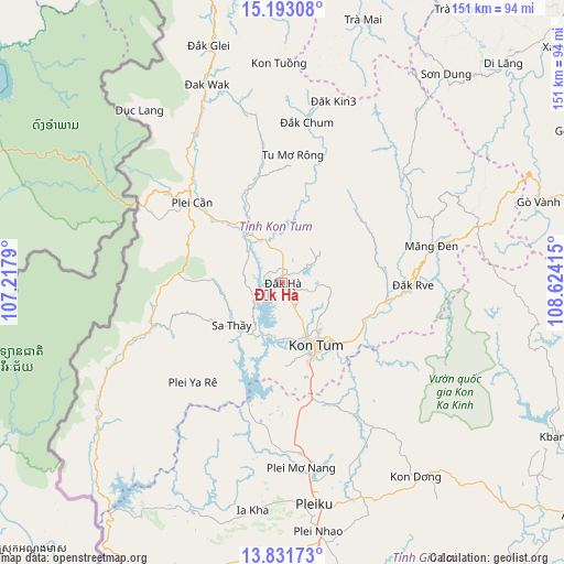
Đắk Hà GPS coordinates[2]
14° 30' 48.42" North, 107° 55' 15.672" East
| Map corner | latitude | longitude |
|---|---|---|
| Upper-left | 15.19308°, | 107.2179° |
| Center: | 14.51345°, | 107.92102° |
| Lower-right: | 13.83173°, | 108.62415° |
| Map W x H: | 151.4×151.4 km | = 94.1×94.1mi |
| max Lat: | 23.27841° ⇑58.4% North |
| Đắk Hà: | 14.51345° |
| min Lat: | ⇓41.6% South 8.65724° |
| min Long | Đắk Hà | max Long |
| 102.4579° | 107.92102° | 112.72541° |
| W 84%⇐ | ⇒16% E |
Elevation
Elevation of Đắk Hà is 602 m = 1975 ft, and this is 472.5 m = 1550 ft above average elevation for this country.
| Max E: |
1592 m = 5223 ft | 6.7% |
| Đắk Hà | 602 m 1975 ft | |
| Avg. | 129.5 m = 425 ft | |
Min E: |
-1 m = -3 ft | 93.3% |
See also: Vietnam elevation on elevation.city.
Geographical zone
Đắk Hà is located in North Torrid zone (between Equator and Tropic of Cancer). Distance of this Northern Tropic circle is 992.2 km =616.5 mi to North.| Distance of | km | miles | from Đắk Hà |
|---|---|---|---|
| North Pole | 8393.3 | 5215.4 | to North |
| Arctic Circle | 5787.4 | 3596.1 | to North |
| Tropic Cancer | 992.2 | 616.5 | to North |
| Equator | 1613.7 | 1002.7 | to South |


Nearby cities:
15 places around Đắk Hà: (largest is in red/bold)
• Chư Ty
82.4 km =51.2 mi,  197°
197°
• Ia Kha
61.8 km =38.4 mi,  187°
187°
• K Bang
83.8 km =52.1 mi,  119°
119°
• Kon Dơng
63.6 km =39.5 mi,  146°
146°
• Kon Tum
20 km =12.4 mi, 152°
• Măng Đen
41 km =25.5 mi,  76°
76°
• Phú Hòa
46.3 km =28.8 mi,  173°
173°
• Plei Kần
33 km =20.5 mi,  310°
310°
• Pleiku
59.6 km =37 mi, 171°
• Sa Thầy
17.7 km =11 mi,  231°
231°
• Sơn Hà
83.3 km =51.8 mi,  45°
45°
• Đăk Đoa
61.2 km =38 mi,  160°
160°
• Đắk Glei
66.7 km =41.4 mi,  342°
342°
• Đắk Rve
35.1 km =21.8 mi,  91°
91°
• Đắk Tô
18.6 km =11.6 mi,  331°
331°
Sources, notices
• [Note1] Compared only with cities in Vietnam existing in our database
• [Src1] Map data: © OpenStreetMap contributors (CC-BY-SA)
• [Src2] Other city data from geonames.org with taken over terms of usage.
• [Src3] Geographical zone / Annual Mean Temperature by Robert A. Rohde @ Wikipedia
