Quận Phú Nhuận geodata
Quận Phú Nhuận (Ho Chi Minh) is a seat of a second-order administrative division; located in Vietnam in Asia/Ho_Chi_Minh (GMT+7) time zone. In our database, there are 94 cities with bigger population. Compared to other cities in Vietnam, 78.3% of cities are located further ↑North; 68.7% of cities are located further ←West and 80.8% of cities have higher elevation than Quận Phú Nhuận. Note1


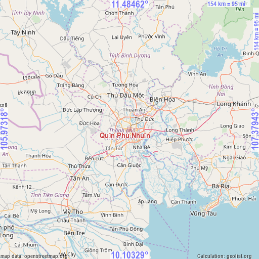
Quận Phú Nhuận GPS coordinates[2]
10° 47' 41.1" North, 106° 40' 34.68" East
| Map corner | latitude | longitude |
|---|---|---|
| Upper-left | 11.48462°, | 105.97318° |
| Center: | 10.79475°, | 106.6763° |
| Lower-right: | 10.10329°, | 107.37943° |
| Map W x H: | 153.6×153.6 km | = 95.4×95.4mi |
| max Lat: | 23.27841° ⇑78.3% North |
| Quận Phú Nhuận: | 10.79475° |
| min Lat: | ⇓21.7% South 8.65724° |
| min Long | Quận Phú Nhu | max Long |
| 102.4579° | 106.6763° | 112.72541° |
| W 68.7%⇐ | ⇒31.3% E |
Elevation
Elevation of Quận Phú Nhuận is 6 m = 20 ft, and this is 123.5 m = 405 ft below average elevation for this country.
| Max E: |
1592 m = 5223 ft | 80.8% |
| Avg. | 129.5 m = 425 ft | |
| Quận Phú Nhuận | 6 m = 20 ft | |
Min E: |
-1 m = -3 ft | 19.2% |
See also: Vietnam elevation on elevation.city.
Geographical zone
Quận Phú Nhuận is located in North Torrid zone (between Equator and Tropic of Cancer). Distance of Equator is 1200.3 km =745.8 mi to South.| Distance of | km | miles | from Quận Phú Nhuận |
|---|---|---|---|
| North Pole | 8806.8 | 5472.3 | to North |
| Arctic Circle | 6200.9 | 3853.1 | to North |
| Tropic Cancer | 1405.7 | 873.5 | to North |
| Equator | 1200.3 | 745.8 | to South |


Nearby cities:
15 places around Quận Phú Nhuận: (largest is in red/bold)
• Ho Chi Minh City
6 km =3.7 mi,  301°
301°
• Lái Thiêu
12.5 km =7.8 mi,  11°
11°
• Quận Ba
2.5 km =1.6 mi,  153°
153°
• Quận Bình Thạnh
2.4 km =1.5 mi,  66°
66°
• Quận Bảy
11.3 km =7 mi,  144°
144°
• Quận Bốn
4.5 km =2.8 mi,  133°
133°
• Quận Chín
11.5 km =7.1 mi,  64°
64°
• Quận Hai
8 km =5 mi,  92°
92°
• Quận Mười
3.1 km =1.9 mi,  200°
200°
• Quận Mười Một
5 km =3.1 mi,  226°
226°
• Quận Một
3 km =1.9 mi,  121°
121°
• Quận Năm
4.5 km =2.8 mi,  192°
192°
• Quận Sáu
6.1 km =3.8 mi,  209°
209°
• Quận Tân Phú
4.5 km =2.8 mi,  254°
254°
• Thủ Đức
12.1 km =7.5 mi, 60°
Sources, notices
• [Note1] Compared only with cities in Vietnam existing in our database
• [Src1] Map data: © OpenStreetMap contributors (CC-BY-SA)
• [Src2] Other city data from geonames.org with taken over terms of usage.
• [Src3] Geographical zone / Annual Mean Temperature by Robert A. Rohde @ Wikipedia
