Lái Thiêu geodata
Lái Thiêu (Bình Dương) is a seat of a second-order administrative division; located in Vietnam in Asia/Ho_Chi_Minh (GMT+7) time zone. In our database, there are 94 cities with bigger population. Compared to other cities in Vietnam, 76% of cities are located further ↑North; 69.7% of cities are located further ←West and 58.1% of cities have higher elevation than Lái Thiêu. Note1


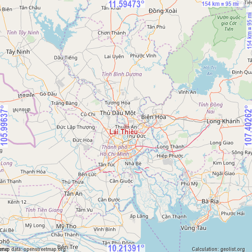
Lái Thiêu GPS coordinates[2]
10° 54' 18.432" North, 106° 41' 58.164" East
| Map corner | latitude | longitude |
|---|---|---|
| Upper-left | 11.59473°, | 105.99637° |
| Center: | 10.90512°, | 106.69949° |
| Lower-right: | 10.21391°, | 107.40262° |
| Map W x H: | 153.5×153.5 km | = 95.4×95.4mi |
| max Lat: | 23.27841° ⇑76% North |
| Lái Thiêu: | 10.90512° |
| min Lat: | ⇓24% South 8.65724° |
| min Long | Lái Thiêu | max Long |
| 102.4579° | 106.69949° | 112.72541° |
| W 69.7%⇐ | ⇒30.3% E |
Elevation
Elevation of Lái Thiêu is 11 m = 36 ft, and this is 118.5 m = 389 ft below average elevation for this country.
| Max E: |
1592 m = 5223 ft | 58.1% |
| Avg. | 129.5 m = 425 ft | |
| Lái Thiêu | 11 m = 36 ft | |
Min E: |
-1 m = -3 ft | 41.9% |
See also: Vietnam elevation on elevation.city.
Geographical zone
Lái Thiêu is located in North Torrid zone (between Equator and Tropic of Cancer). Distance of Equator is 1212.5 km =753.4 mi to South.| Distance of | km | miles | from Lái Thiêu |
|---|---|---|---|
| North Pole | 8794.5 | 5464.6 | to North |
| Arctic Circle | 6188.6 | 3845.4 | to North |
| Tropic Cancer | 1393.4 | 865.8 | to North |
| Equator | 1212.5 | 753.4 | to South |


Nearby cities:
15 places around Lái Thiêu: (largest is in red/bold)
• Biên Hòa
14.3 km =8.9 mi,  72°
72°
• Dĩ An
7.6 km =4.7 mi,  88°
88°
• Ho Chi Minh City
11.9 km =7.4 mi,  219°
219°
• Hóc Môn
11.5 km =7.1 mi,  261°
261°
• Quận Ba
14.5 km =9 mi,  185°
185°
• Quận Bình Thạnh
11.3 km =7 mi,  181°
181°
• Quận Bốn
15.4 km =9.6 mi, 177°
• Quận Chín
10.7 km =6.6 mi,  132°
132°
• Quận Hai
13.8 km =8.6 mi,  156°
156°
• Quận Mười
15.6 km =9.7 mi, 193°
• Quận Một
13.8 km =8.6 mi, 180°
• Quận Phú Nhuận
12.5 km =7.8 mi, 191°
• Quận Tân Phú
15.1 km =9.4 mi,  206°
206°
• Thủ Dầu Một
9.9 km =6.2 mi,  328°
328°
• Thủ Đức
10.1 km =6.3 mi, 128°
Sources, notices
• [Note1] Compared only with cities in Vietnam existing in our database
• [Src1] Map data: © OpenStreetMap contributors (CC-BY-SA)
• [Src2] Other city data from geonames.org with taken over terms of usage.
• [Src3] Geographical zone / Annual Mean Temperature by Robert A. Rohde @ Wikipedia
