Vĩnh Thạnh geodata
Vĩnh Thạnh (Bình Định) is a seat of a second-order administrative division; located in Vietnam in Asia/Ho_Chi_Minh (GMT+7) time zone. In our database, there are 94 cities with bigger population. Compared to other cities in Vietnam, 59.7% of cities are located further ↑North; 94% of cities are located further ←West and 71% of cities have lower elevation than Vĩnh Thạnh. Note1


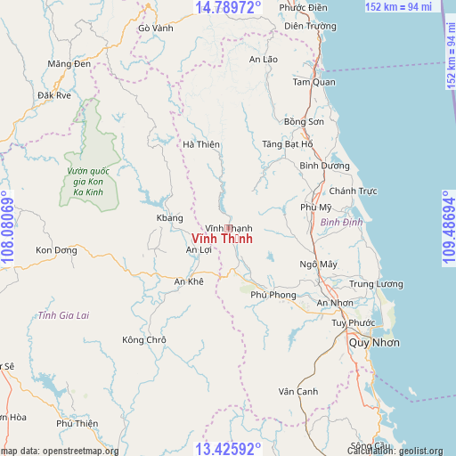
Vĩnh Thạnh GPS coordinates[2]
14° 6' 31.824" North, 108° 47' 1.716" East
| Map corner | latitude | longitude |
|---|---|---|
| Upper-left | 14.78972°, | 108.08069° |
| Center: | 14.10884°, | 108.78381° |
| Lower-right: | 13.42592°, | 109.48694° |
| Map W x H: | 151.6×151.6 km | = 94.2×94.2mi |
| max Lat: | 23.27841° ⇑59.7% North |
| Vĩnh Thạnh: | 14.10884° |
| min Lat: | ⇓40.3% South 8.65724° |
| min Long | Vĩnh Thạnh | max Long |
| 102.4579° | 108.78381° | 112.72541° |
| W 94%⇐ | ⇒6% E |
Elevation
Elevation of Vĩnh Thạnh is 61 m = 200 ft, and this is 68.5 m = 225 ft below average elevation for this country.
| Max E: |
1592 m = 5223 ft | 29% |
| Avg. | 129.5 m = 425 ft | |
| Vĩnh Thạnh | 61 m = 200 ft | |
Min E: |
-1 m = -3 ft | 71% |
See also: Vietnam elevation on elevation.city.
Geographical zone
Vĩnh Thạnh is located in North Torrid zone (between Equator and Tropic of Cancer). Distance of this Northern Tropic circle is 1037.2 km =644.5 mi to North.| Distance of | km | miles | from Vĩnh Thạnh |
|---|---|---|---|
| North Pole | 8438.3 | 5243.3 | to North |
| Arctic Circle | 5832.4 | 3624.1 | to North |
| Tropic Cancer | 1037.2 | 644.5 | to North |
| Equator | 1568.8 | 974.8 | to South |


Nearby cities:
15 places around Vĩnh Thạnh: (largest is in red/bold)
• An Lão
57.1 km =35.5 mi,  11°
11°
• An Nhơn
42.9 km =26.7 mi,  125°
125°
• Ba Tơ
73 km =45.4 mi,  355°
355°
• Bồng Sơn
43.5 km =27 mi,  35°
35°
• Hoài Ân
34.4 km =21.4 mi,  34°
34°
• K Bang
20.3 km =12.6 mi,  281°
281°
• Kon Dơng
58.1 km =36.1 mi,  262°
262°
• Kông Chro
46.4 km =28.8 mi,  216°
216°
• Phù Cát
31.8 km =19.8 mi,  111°
111°
• Phù Mỹ
29.4 km =18.3 mi,  76°
76°
• Phú Phong
26.5 km =16.5 mi,  146°
146°
• Qui Nhon
60.2 km =37.4 mi, 127°
• Tuy Phước
51.8 km =32.2 mi, 127°
• Vân Canh
59.1 km =36.7 mi,  156°
156°
• Đắk Rve
72.8 km =45.2 mi,  307°
307°
Sources, notices
• [Note1] Compared only with cities in Vietnam existing in our database
• [Src1] Map data: © OpenStreetMap contributors (CC-BY-SA)
• [Src2] Other city data from geonames.org with taken over terms of usage.
• [Src3] Geographical zone / Annual Mean Temperature by Robert A. Rohde @ Wikipedia
