Bồng Sơn geodata
Bồng Sơn (Bình Định) is a seat of a second-order administrative division; located in Vietnam in Asia/Ho_Chi_Minh (GMT+7) time zone. In our database, there are 94 cities with bigger population. Compared to other cities in Vietnam, 58.7% of cities are located further ↑North; 97.1% of cities are located further ←West and 53.3% of cities have lower elevation than Bồng Sơn. Note1


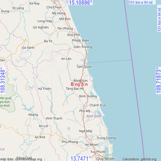
Bồng Sơn GPS coordinates[2]
14° 25' 44.652" North, 109° 0' 56.16" East
| Map corner | latitude | longitude |
|---|---|---|
| Upper-left | 15.10896°, | 108.31248° |
| Center: | 14.42907°, | 109.0156° |
| Lower-right: | 13.7471°, | 109.71873° |
| Map W x H: | 151.4×151.4 km | = 94.1×94.1mi |
| max Lat: | 23.27841° ⇑58.7% North |
| Bồng Sơn: | 14.42907° |
| min Lat: | ⇓41.3% South 8.65724° |
| min Long | Bồng Sơn | max Long |
| 102.4579° | 109.0156° | 112.72541° |
| W 97.1%⇐ | ⇒2.9% E |
Elevation
Elevation of Bồng Sơn is 16 m = 52 ft, and this is 113.5 m = 372 ft below average elevation for this country.
| Max E: |
1592 m = 5223 ft | 46.7% |
| Avg. | 129.5 m = 425 ft | |
| Bồng Sơn | 16 m = 52 ft | |
Min E: |
-1 m = -3 ft | 53.3% |
See also: Vietnam elevation on elevation.city.
Geographical zone
Bồng Sơn is located in North Torrid zone (between Equator and Tropic of Cancer). Distance of this Northern Tropic circle is 1001.6 km =622.4 mi to North.| Distance of | km | miles | from Bồng Sơn |
|---|---|---|---|
| North Pole | 8402.7 | 5221.2 | to North |
| Arctic Circle | 5796.8 | 3602 | to North |
| Tropic Cancer | 1001.6 | 622.4 | to North |
| Equator | 1604.4 | 996.9 | to South |


Nearby cities:
15 places around Bồng Sơn: (largest is in red/bold)
• An Lão
24.5 km =15.2 mi,  326°
326°
• An Nhơn
61.2 km =38 mi,  170°
170°
• Ba Tơ
48.1 km =29.9 mi,  320°
320°
• Hoài Ân
9.1 km =5.7 mi,  216°
216°
• K Bang
54.9 km =34.1 mi,  234°
234°
• Minh Long
65.3 km =40.6 mi, 329°
• Mộ Đức
60.1 km =37.3 mi,  346°
346°
• Nghĩa Hành
73.2 km =45.5 mi,  339°
339°
• Pho Duc
43.2 km =26.8 mi, 351°
• Phù Cát
47.6 km =29.6 mi, 174°
• Phù Mỹ
28.8 km =17.9 mi, 172°
• Phú Phong
58.7 km =36.5 mi,  190°
190°
• Tuy Phước
68.9 km =42.8 mi, 166°
• Tư Nghĩa
75.7 km =47 mi, 344°
• Vĩnh Thạnh
43.5 km =27 mi, 215°
Sources, notices
• [Note1] Compared only with cities in Vietnam existing in our database
• [Src1] Map data: © OpenStreetMap contributors (CC-BY-SA)
• [Src2] Other city data from geonames.org with taken over terms of usage.
• [Src3] Geographical zone / Annual Mean Temperature by Robert A. Rohde @ Wikipedia
