Qui Nhon geodata
Qui Nhon (Bình Định) is a seat of a first-order administrative division; located in Vietnam in Asia/Ho_Chi_Minh (GMT+7) time zone. With population of 210,338 people, there are 10 cities with bigger population in this country. Compared to other cities in Vietnam, 61.5% of cities are located further ↑North; 99.7% of cities are located further ←West and 75% of cities have higher elevation than Qui Nhon. Note1


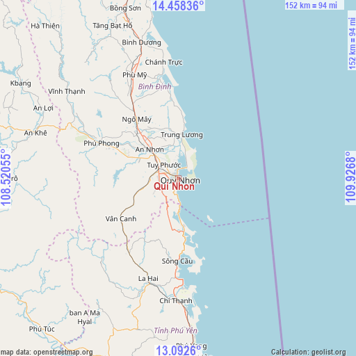
Qui Nhon GPS coordinates[2]
13° 46' 35.328" North, 109° 13' 25.212" East
| Map corner | latitude | longitude |
|---|---|---|
| Upper-left | 14.45836°, | 108.52055° |
| Center: | 13.77648°, | 109.22367° |
| Lower-right: | 13.0926°, | 109.9268° |
| Map W x H: | 151.9×151.9 km | = 94.4×94.4mi |
| max Lat: | 23.27841° ⇑61.5% North |
| Qui Nhon: | 13.77648° |
| min Lat: | ⇓38.5% South 8.65724° |
| min Long | Qui Nhon | max Long |
| 102.4579° | 109.22367° | 112.72541° |
| W 99.7%⇐ | ⇒0.3% E |
Elevation
Elevation of Qui Nhon is 7 m = 23 ft, and this is 122.5 m = 402 ft below average elevation for this country.
| Max E: |
1592 m = 5223 ft | 75% |
| Avg. | 129.5 m = 425 ft | |
| Qui Nhon | 7 m = 23 ft | |
Min E: |
-1 m = -3 ft | 25% |
See also: Qui Nhon elevation on elevation.city.
Geographical zone
Qui Nhon is located in North Torrid zone (between Equator and Tropic of Cancer). Distance of this Northern Tropic circle is 1074.1 km =667.4 mi to North.| Distance of | km | miles | from Qui Nhon |
|---|---|---|---|
| North Pole | 8475.3 | 5266.3 | to North |
| Arctic Circle | 5869.4 | 3647.1 | to North |
| Tropic Cancer | 1074.1 | 667.4 | to North |
| Equator | 1531.8 | 951.8 | to South |


Nearby cities:
15 places around Qui Nhon: (largest is in red/bold)
• An Nhơn
17.4 km =10.8 mi,  314°
314°
• Bồng Sơn
76 km =47.2 mi,  342°
342°
• Chí Thạnh
52 km =32.3 mi,  181°
181°
• Hoài Ân
71 km =44.1 mi, 336°
• K Bang
78.8 km =49 mi,  301°
301°
• Kông Chro
75.4 km =46.9 mi,  269°
269°
• La Hai
46.1 km =28.6 mi,  195°
195°
• Phù Cát
30.9 km =19.2 mi,  324°
324°
• Phù Mỹ
47.8 km =29.7 mi, 336°
• Phú Phong
36.1 km =22.4 mi,  294°
294°
• Sông Cầu
35.7 km =22.2 mi, 180°
• Tuy Hòa
76.4 km =47.5 mi,  172°
172°
• Tuy Phước
8.4 km =5.2 mi, 312°
• Vân Canh
30 km =18.6 mi,  234°
234°
• Vĩnh Thạnh
60.2 km =37.4 mi, 307°
Sources, notices
• [Note1] Compared only with cities in Vietnam existing in our database
• [Src1] Map data: © OpenStreetMap contributors (CC-BY-SA)
• [Src2] Other city data from geonames.org with taken over terms of usage.
• [Src3] Geographical zone / Annual Mean Temperature by Robert A. Rohde @ Wikipedia
