Nghèn geodata
Nghèn (Hà Tĩnh) is a seat of a second-order administrative division; located in Vietnam in Asia/Ho_Chi_Minh (GMT+7) time zone. In our database, there are 94 cities with bigger population. Compared to other cities in Vietnam, 53.2% of cities are located further ↓South; 64.4% of cities are located further →East and 71.9% of cities have higher elevation than Nghèn. Note1


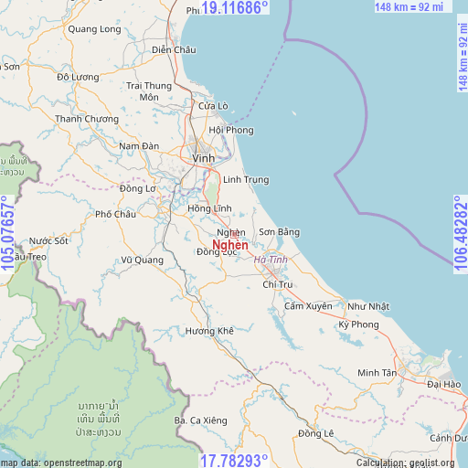
Nghèn GPS coordinates[2]
18° 27' 4.284" North, 105° 46' 46.884" East
| Map corner | latitude | longitude |
|---|---|---|
| Upper-left | 19.11686°, | 105.07657° |
| Center: | 18.45119°, | 105.77969° |
| Lower-right: | 17.78293°, | 106.48282° |
| Map W x H: | 148.3×148.3 km | = 92.1×92.1mi |
| max Lat: | 23.27841° ⇑46.8% North |
| Nghèn: | 18.45119° |
| min Lat: | ⇓53.2% South 8.65724° |
| min Long | Nghèn | max Long |
| 102.4579° | 105.77969° | 112.72541° |
| W 35.6%⇐ | ⇒64.4% E |
Elevation
Elevation of Nghèn is 8 m = 26 ft, and this is 121.5 m = 399 ft below average elevation for this country.
| Max E: |
1592 m = 5223 ft | 71.9% |
| Avg. | 129.5 m = 425 ft | |
| Nghèn | 8 m = 26 ft | |
Min E: |
-1 m = -3 ft | 28.1% |
See also: Vietnam elevation on elevation.city.
Geographical zone
Nghèn is located in North Torrid zone (between Equator and Tropic of Cancer). Distance of this Northern Tropic circle is 554.3 km =344.4 mi to North.| Distance of | km | miles | from Nghèn |
|---|---|---|---|
| North Pole | 7955.5 | 4943.3 | to North |
| Arctic Circle | 5349.6 | 3324.1 | to North |
| Tropic Cancer | 554.3 | 344.4 | to North |
| Equator | 2051.6 | 1274.8 | to South |


Nearby cities:
15 places around Nghèn: (largest is in red/bold)
• Cẩm Xuyên
32.3 km =20.1 mi,  133°
133°
• Diễn Châu
61.4 km =38.2 mi,  342°
342°
• Hà Tĩnh
17.9 km =11.1 mi, 132°
• Hưng Nguyên
29.2 km =18.1 mi,  327°
327°
• Hương Khê
31.7 km =19.7 mi,  195°
195°
• Nam Đàn
40.4 km =25.1 mi,  312°
312°
• Nghi Xuân
23.6 km =14.7 mi,  353°
353°
• Phố Châu
38.1 km =23.7 mi,  280°
280°
• Quán Hành
39.1 km =24.3 mi, 338°
• Thanh Chương
59.5 km =37 mi, 307°
• Thạch Hà
12.6 km =7.8 mi,  137°
137°
• Vinh
26.4 km =16.4 mi, 339°
• Vũ Quang
29.8 km =18.5 mi,  255°
255°
• Yên Vinh
26.8 km =16.7 mi, 333°
• Đức Thọ
22.9 km =14.2 mi,  295°
295°
Sources, notices
• [Note1] Compared only with cities in Vietnam existing in our database
• [Src1] Map data: © OpenStreetMap contributors (CC-BY-SA)
• [Src2] Other city data from geonames.org with taken over terms of usage.
• [Src3] Geographical zone / Annual Mean Temperature by Robert A. Rohde @ Wikipedia
