Hà Tĩnh geodata
Hà Tĩnh is a seat of a first-order administrative division; located in Vietnam in Asia/Ho_Chi_Minh (GMT+7) time zone. With population of 27,728 people, there are 77 cities with bigger population in this country. Compared to other cities in Vietnam, 52.7% of cities are located further ↓South; 59.2% of cities are located further →East and 71.9% of cities have higher elevation than Hà Tĩnh. Note1


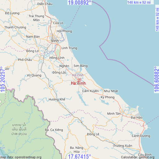
Hà Tĩnh GPS coordinates[2]
18° 20' 34.152" North, 105° 54' 20.484" East
| Map corner | latitude | longitude |
|---|---|---|
| Upper-left | 19.00892°, | 105.20257° |
| Center: | 18.34282°, | 105.90569° |
| Lower-right: | 17.67415°, | 106.60882° |
| Map W x H: | 148.4×148.4 km | = 92.2×92.2mi |
| max Lat: | 23.27841° ⇑47.3% North |
| Hà Tĩnh: | 18.34282° |
| min Lat: | ⇓52.7% South 8.65724° |
| min Long | Hà Tĩnh | max Long |
| 102.4579° | 105.90569° | 112.72541° |
| W 40.8%⇐ | ⇒59.2% E |
Elevation
Elevation of Hà Tĩnh is 8 m = 26 ft, and this is 121.5 m = 399 ft below average elevation for this country.
| Max E: |
1592 m = 5223 ft | 71.9% |
| Avg. | 129.5 m = 425 ft | |
| Hà Tĩnh | 8 m = 26 ft | |
Min E: |
-1 m = -3 ft | 28.1% |
See also: Vietnam elevation on elevation.city.
Geographical zone
Hà Tĩnh is located in North Torrid zone (between Equator and Tropic of Cancer). Distance of this Northern Tropic circle is 566.4 km =351.9 mi to North.| Distance of | km | miles | from Hà Tĩnh |
|---|---|---|---|
| North Pole | 7967.5 | 4950.8 | to North |
| Arctic Circle | 5361.6 | 3331.5 | to North |
| Tropic Cancer | 566.4 | 351.9 | to North |
| Equator | 2039.5 | 1267.3 | to South |


Nearby cities:
15 places around Hà Tĩnh: (largest is in red/bold)
• Cẩm Xuyên
14.4 km =8.9 mi,  135°
135°
• Hưng Nguyên
46.8 km =29.1 mi,  321°
321°
• Hương Khê
28.5 km =17.7 mi,  229°
229°
• Kỳ Anh
51.9 km =32.2 mi,  126°
126°
• Nam Đàn
58.3 km =36.2 mi,  312°
312°
• Nghi Xuân
38.9 km =24.2 mi,  335°
335°
• Nghèn
17.9 km =11.1 mi, 312°
• Phố Châu
54.2 km =33.7 mi,  290°
290°
• Quán Hành
55.7 km =34.6 mi,  330°
330°
• Thạch Hà
5.5 km =3.4 mi,  300°
300°
• Vinh
43.1 km =26.8 mi, 328°
• Vũ Quang
42.4 km =26.3 mi,  276°
276°
• Yên Vinh
44 km =27.3 mi, 325°
• Đồng Lê
52.6 km =32.7 mi,  166°
166°
• Đức Thọ
40.5 km =25.2 mi, 302°
In other languages:
- In France: Province de Hà Tĩnh
- In German: Ha Thin
- In Russian: Хатинь
- In Chinese: 河靜市
Sources, notices
• [Note1] Compared only with cities in Vietnam existing in our database
• [Src1] Map data: © OpenStreetMap contributors (CC-BY-SA)
• [Src2] Other city data from geonames.org with taken over terms of usage.
• [Src3] Geographical zone / Annual Mean Temperature by Robert A. Rohde @ Wikipedia
