Thường Xuân geodata
Thường Xuân (Thanh Hóa) is a seat of a second-order administrative division; located in Vietnam in Asia/Ho_Chi_Minh (GMT+7) time zone. In our database, there are 94 cities with bigger population. Compared to other cities in Vietnam, 58.2% of cities are located further ↓South; 81.7% of cities are located further →East and 64.9% of cities have lower elevation than Thường Xuân. Note1


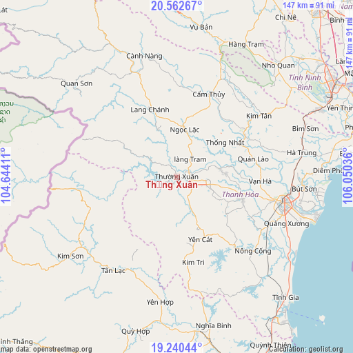
Thường Xuân GPS coordinates[2]
19° 54' 10.584" North, 105° 20' 50.028" East
| Map corner | latitude | longitude |
|---|---|---|
| Upper-left | 20.56267°, | 104.64411° |
| Center: | 19.90294°, | 105.34723° |
| Lower-right: | 19.24044°, | 106.05036° |
| Map W x H: | 147×147 km | = 91.3×91.3mi |
| max Lat: | 23.27841° ⇑41.8% North |
| Thường Xuân: | 19.90294° |
| min Lat: | ⇓58.2% South 8.65724° |
| min Long | Thường Xuân | max Long |
| 102.4579° | 105.34723° | 112.72541° |
| W 18.3%⇐ | ⇒81.7% E |
Elevation
Elevation of Thường Xuân is 34 m = 112 ft, and this is 95.5 m = 313 ft below average elevation for this country.
| Max E: |
1592 m = 5223 ft | 35.1% |
| Avg. | 129.5 m = 425 ft | |
| Thường Xuân | 34 m = 112 ft | |
Min E: |
-1 m = -3 ft | 64.9% |
See also: Vietnam elevation on elevation.city.
Geographical zone
Thường Xuân is located in North Torrid zone (between Equator and Tropic of Cancer). Distance of this Northern Tropic circle is 392.9 km =244.1 mi to North.| Distance of | km | miles | from Thường Xuân |
|---|---|---|---|
| North Pole | 7794.1 | 4843 | to North |
| Arctic Circle | 5188.2 | 3223.8 | to North |
| Tropic Cancer | 392.9 | 244.1 | to North |
| Equator | 2213 | 1375.1 | to South |


Nearby cities:
15 places around Thường Xuân: (largest is in red/bold)
• Bến Sung
38.7 km =24 mi,  141°
141°
• Cẩm Thủy
36.3 km =22.6 mi,  20°
20°
• Kim Tân
42.5 km =26.4 mi,  53°
53°
• Lang Chánh
30.2 km =18.8 mi,  338°
338°
• Ngọc Lặc
21.1 km =13.1 mi,  5°
5°
• Nông Cống
44.3 km =27.5 mi,  134°
134°
• Quán Lào
32.7 km =20.3 mi,  76°
76°
• Quỳ Châu
47.2 km =29.3 mi,  214°
214°
• Rừng Thông
41.4 km =25.7 mi,  103°
103°
• Thanh Hóa
45.3 km =28.1 mi, 104°
• Thọ Xuân
18.5 km =11.5 mi, 80°
• Triệu Sơn
28.4 km =17.6 mi,  109°
109°
• Vĩnh Lộc
32.7 km =20.3 mi,  59°
59°
• Vạn Hà
34.7 km =21.6 mi,  93°
93°
• Yên Cát
28 km =17.4 mi,  162°
162°
Sources, notices
• [Note1] Compared only with cities in Vietnam existing in our database
• [Src1] Map data: © OpenStreetMap contributors (CC-BY-SA)
• [Src2] Other city data from geonames.org with taken over terms of usage.
• [Src3] Geographical zone / Annual Mean Temperature by Robert A. Rohde @ Wikipedia
