Ngọc Lặc geodata
Ngọc Lặc (Thanh Hóa) is a seat of a second-order administrative division; located in Vietnam in Asia/Ho_Chi_Minh (GMT+7) time zone. In our database, there are 94 cities with bigger population. Compared to other cities in Vietnam, 59.7% of cities are located further ↓South; 81.1% of cities are located further →East and 68.4% of cities have lower elevation than Ngọc Lặc. Note1


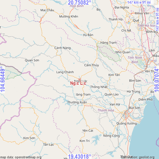
Ngọc Lặc GPS coordinates[2]
20° 5' 30.804" North, 105° 22' 3.396" East
| Map corner | latitude | longitude |
|---|---|---|
| Upper-left | 20.75082°, | 104.66449° |
| Center: | 20.09189°, | 105.36761° |
| Lower-right: | 19.43018°, | 106.07074° |
| Map W x H: | 146.8×146.8 km | = 91.2×91.2mi |
| max Lat: | 23.27841° ⇑40.3% North |
| Ngọc Lặc: | 20.09189° |
| min Lat: | ⇓59.7% South 8.65724° |
| min Long | Ngọc Lặc | max Long |
| 102.4579° | 105.36761° | 112.72541° |
| W 18.9%⇐ | ⇒81.1% E |
Elevation
Elevation of Ngọc Lặc is 50 m = 164 ft, and this is 79.5 m = 261 ft below average elevation for this country.
| Max E: |
1592 m = 5223 ft | 31.6% |
| Avg. | 129.5 m = 425 ft | |
| Ngọc Lặc | 50 m = 164 ft | |
Min E: |
-1 m = -3 ft | 68.4% |
See also: Vietnam elevation on elevation.city.
Geographical zone
Ngọc Lặc is located in North Torrid zone (between Equator and Tropic of Cancer). Distance of this Northern Tropic circle is 371.9 km =231.1 mi to North.| Distance of | km | miles | from Ngọc Lặc |
|---|---|---|---|
| North Pole | 7773.1 | 4830 | to North |
| Arctic Circle | 5167.2 | 3210.7 | to North |
| Tropic Cancer | 371.9 | 231.1 | to North |
| Equator | 2234 | 1388.1 | to South |


Nearby cities:
15 places around Ngọc Lặc: (largest is in red/bold)
• Cành Nàng
32 km =19.9 mi,  333°
333°
• Cẩm Thủy
16.8 km =10.4 mi,  39°
39°
• Hàng Trạm
42.9 km =26.7 mi, 38°
• Kim Tân
32.3 km =20.1 mi,  82°
82°
• Lang Chánh
14.9 km =9.3 mi,  298°
298°
• Nho Quan
47.6 km =29.6 mi,  57°
57°
• Quan Hóa
42.9 km =26.7 mi,  319°
319°
• Quan Sơn
47.8 km =29.7 mi,  292°
292°
• Quán Lào
32.5 km =20.2 mi,  114°
114°
• Thường Xuân
21.1 km =13.1 mi,  185°
185°
• Thọ Xuân
24 km =14.9 mi,  137°
137°
• Triệu Sơn
39.1 km =24.3 mi, 140°
• Vĩnh Lộc
26.2 km =16.3 mi,  99°
99°
• Vạn Hà
39.7 km =24.7 mi,  125°
125°
• Vụ Bản
42.1 km =26.2 mi,  10°
10°
Sources, notices
• [Note1] Compared only with cities in Vietnam existing in our database
• [Src1] Map data: © OpenStreetMap contributors (CC-BY-SA)
• [Src2] Other city data from geonames.org with taken over terms of usage.
• [Src3] Geographical zone / Annual Mean Temperature by Robert A. Rohde @ Wikipedia
