Nhà Bè geodata
Nhà Bè (Ho Chi Minh) is a seat of a second-order administrative division; located in Vietnam in Asia/Ho_Chi_Minh (GMT+7) time zone. In our database, there are 94 cities with bigger population. Compared to other cities in Vietnam, 80.6% of cities are located further ↑North; 70.5% of cities are located further ←West and 95.4% of cities have higher elevation than Nhà Bè. Note1


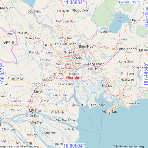
Nhà Bè GPS coordinates[2]
10° 41' 48.192" North, 106° 44' 25.152" East
| Map corner | latitude | longitude |
|---|---|---|
| Upper-left | 11.38682°, | 106.0372° |
| Center: | 10.69672°, | 106.74032° |
| Lower-right: | 10.00504°, | 107.44345° |
| Map W x H: | 153.6×153.6 km | = 95.4×95.4mi |
| max Lat: | 23.27841° ⇑80.6% North |
| Nhà Bè: | 10.69672° |
| min Lat: | ⇓19.4% South 8.65724° |
| min Long | Nhà Bè | max Long |
| 102.4579° | 106.74032° | 112.72541° |
| W 70.5%⇐ | ⇒29.5% E |
Elevation
Elevation of Nhà Bè is 3 m = 10 ft, and this is 126.5 m = 415 ft below average elevation for this country.
| Max E: |
1592 m = 5223 ft | 95.4% |
| Avg. | 129.5 m = 425 ft | |
| Nhà Bè | 3 m = 10 ft | |
Min E: |
-1 m = -3 ft | 4.6% |
See also: Vietnam elevation on elevation.city.
Geographical zone
Nhà Bè is located in North Torrid zone (between Equator and Tropic of Cancer). Distance of Equator is 1189.4 km =739.1 mi to South.| Distance of | km | miles | from Nhà Bè |
|---|---|---|---|
| North Pole | 8817.7 | 5479.1 | to North |
| Arctic Circle | 6211.8 | 3859.8 | to North |
| Tropic Cancer | 1416.6 | 880.2 | to North |
| Equator | 1189.4 | 739.1 | to South |


Nearby cities:
15 places around Nhà Bè: (largest is in red/bold)
• Cần Giuộc
12.4 km =7.7 mi,  217°
217°
• Nhơn Trạch
15.9 km =9.9 mi,  79°
79°
• Quận Ba
10.5 km =6.5 mi,  325°
325°
• Quận Bình Thạnh
12.8 km =8 mi,  338°
338°
• Quận Bảy
1.7 km =1.1 mi,  345°
345°
• Quận Bốn
8.7 km =5.4 mi, 334°
• Quận Chín
16.2 km =10.1 mi,  11°
11°
• Quận Hai
10.6 km =6.6 mi, 5°
• Quận Mười
11.3 km =7 mi,  314°
314°
• Quận Mười Một
12.9 km =8 mi, 305°
• Quận Một
10.3 km =6.4 mi, 334°
• Quận Năm
10.3 km =6.4 mi, 309°
• Quận Phú Nhuận
13 km =8.1 mi, 327°
• Quận Sáu
11.4 km =7.1 mi,  299°
299°
• Quận Tân Phú
14.9 km =9.3 mi, 310°
Sources, notices
• [Note1] Compared only with cities in Vietnam existing in our database
• [Src1] Map data: © OpenStreetMap contributors (CC-BY-SA)
• [Src2] Other city data from geonames.org with taken over terms of usage.
• [Src3] Geographical zone / Annual Mean Temperature by Robert A. Rohde @ Wikipedia
