Hanoi geodata
Hanoi is a capital of a political entity; located in Vietnam in Asia/Ho_Chi_Minh (GMT+7) time zone. With population of 1,431,270 people, there is 1 city with bigger population in this country. Compared to other cities in Vietnam, 75.5% of cities are located further ↓South; 62.2% of cities are located further →East and 61.7% of cities have higher elevation than Hanoi. Note1


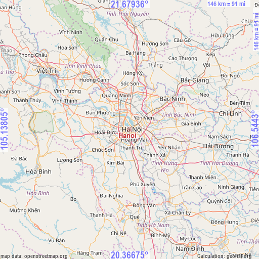
Hanoi GPS coordinates[2]
21° 1' 28.2" North, 105° 50' 28.212" East
| Map corner | latitude | longitude |
|---|---|---|
| Upper-left | 21.67936°, | 105.13805° |
| Center: | 21.0245°, | 105.84117° |
| Lower-right: | 20.36675°, | 106.5443° |
| Map W x H: | 145.9×146 km | = 90.7×90.7mi |
| max Lat: | 23.27841° ⇑24.5% North |
| Hanoi: | 21.0245° |
| min Lat: | ⇓75.5% South 8.65724° |
| min Long | Hanoi | max Long |
| 102.4579° | 105.84117° | 112.72541° |
| W 37.8%⇐ | ⇒62.2% E |
Elevation
Elevation of Hanoi is 10 m = 33 ft, and this is 119.5 m = 392 ft below average elevation for this country.
| Max E: |
1592 m = 5223 ft | 61.7% |
| Avg. | 129.5 m = 425 ft | |
| Hanoi | 10 m = 33 ft | |
Min E: |
-1 m = -3 ft | 38.3% |
See also: Hanoi elevation on elevation.city.
Geographical zone
Hanoi is located in North Torrid zone (between Equator and Tropic of Cancer). Distance of this Northern Tropic circle is 268.2 km =166.7 mi to North.| Distance of | km | miles | from Hanoi |
|---|---|---|---|
| North Pole | 7669.4 | 4765.5 | to North |
| Arctic Circle | 5063.5 | 3146.3 | to North |
| Tropic Cancer | 268.2 | 166.7 | to North |
| Equator | 2337.7 | 1452.6 | to South |


Nearby cities:
15 places around Hanoi: (largest is in red/bold)
• Cầu Diễn
7.9 km =4.9 mi,  281°
281°
• Cầu Giấy
4.3 km =2.7 mi, 281°
• Hai BàTrưng
1.4 km =0.9 mi,  151°
151°
• Hoàn Kiếm
1.1 km =0.7 mi,  65°
65°
• Hà Đông
8.8 km =5.5 mi,  227°
227°
• Như Quỳnh
15.7 km =9.8 mi,  107°
107°
• Phù Ninh
13.1 km =8.1 mi,  59°
59°
• Thanh Xuân
5.4 km =3.4 mi, 232°
• Trâu Quỳ
10 km =6.2 mi,  93°
93°
• Trôi
14.8 km =9.2 mi,  289°
289°
• Tây Hồ
5.9 km =3.7 mi,  327°
327°
• Văn Giang
13 km =8.1 mi,  134°
134°
• Văn Điển
8.7 km =5.4 mi,  177°
177°
• Đông Anh
12.8 km =8 mi,  3°
3°
• Đống Đa
1.2 km =0.7 mi,  245°
245°
Sources, notices
• [Note1] Compared only with cities in Vietnam existing in our database
• [Src1] Map data: © OpenStreetMap contributors (CC-BY-SA)
• [Src2] Other city data from geonames.org with taken over terms of usage.
• [Src3] Geographical zone / Annual Mean Temperature by Robert A. Rohde @ Wikipedia
