Tây Hồ geodata
Tây Hồ (Hanoi) is a seat of a second-order administrative division; located in Vietnam in Asia/Ho_Chi_Minh (GMT+7) time zone. In our database, there are 94 cities with bigger population. Compared to other cities in Vietnam, 77.3% of cities are located further ↓South; 63.3% of cities are located further →East and 52.4% of cities have higher elevation than Tây Hồ. Note1


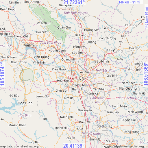
Tây Hồ GPS coordinates[2]
21° 4' 8.22" North, 105° 48' 37.908" East
| Map corner | latitude | longitude |
|---|---|---|
| Upper-left | 21.72361°, | 105.10741° |
| Center: | 21.06895°, | 105.81053° |
| Lower-right: | 20.41139°, | 106.51366° |
| Map W x H: | 145.9×145.9 km | = 90.7×90.7mi |
| max Lat: | 23.27841° ⇑22.7% North |
| Tây Hồ: | 21.06895° |
| min Lat: | ⇓77.3% South 8.65724° |
| min Long | Tây Hồ | max Long |
| 102.4579° | 105.81053° | 112.72541° |
| W 36.7%⇐ | ⇒63.3% E |
Elevation
Elevation of Tây Hồ is 13 m = 43 ft, and this is 116.5 m = 382 ft below average elevation for this country.
| Max E: |
1592 m = 5223 ft | 52.4% |
| Avg. | 129.5 m = 425 ft | |
| Tây Hồ | 13 m = 43 ft | |
Min E: |
-1 m = -3 ft | 47.6% |
See also: Vietnam elevation on elevation.city.
Geographical zone
Tây Hồ is located in North Torrid zone (between Equator and Tropic of Cancer). Distance of this Northern Tropic circle is 263.3 km =163.6 mi to North.| Distance of | km | miles | from Tây Hồ |
|---|---|---|---|
| North Pole | 7664.4 | 4762.4 | to North |
| Arctic Circle | 5058.5 | 3143.2 | to North |
| Tropic Cancer | 263.3 | 163.6 | to North |
| Equator | 2342.6 | 1455.6 | to South |


Nearby cities:
15 places around Tây Hồ: (largest is in red/bold)
• Cầu Diễn
5.6 km =3.5 mi,  234°
234°
• Cầu Giấy
4.2 km =2.6 mi,  194°
194°
• Hai BàTrưng
7.3 km =4.5 mi,  147°
147°
• Hanoi
5.9 km =3.7 mi, 147°
• Hoàn Kiếm
6.1 km =3.8 mi,  137°
137°
• Hà Đông
11.3 km =7 mi,  196°
196°
• Mê Linh
15.8 km =9.8 mi,  323°
323°
• Phù Ninh
14.6 km =9.1 mi,  83°
83°
• Phùng
15.9 km =9.9 mi,  278°
278°
• Thanh Xuân
8.3 km =5.2 mi, 187°
• Trâu Quỳ
14.2 km =8.8 mi,  112°
112°
• Trôi
10.8 km =6.7 mi,  270°
270°
• Văn Điển
14.1 km =8.8 mi,  165°
165°
• Đông Anh
8.8 km =5.5 mi,  27°
27°
• Đống Đa
5.8 km =3.6 mi,  158°
158°
Sources, notices
• [Note1] Compared only with cities in Vietnam existing in our database
• [Src1] Map data: © OpenStreetMap contributors (CC-BY-SA)
• [Src2] Other city data from geonames.org with taken over terms of usage.
• [Src3] Geographical zone / Annual Mean Temperature by Robert A. Rohde @ Wikipedia
