Phù Ninh geodata
Phù Ninh is a populated place; located in Vietnam in Asia/Ho_Chi_Minh (GMT+7) time zone. With population of 4,000 people, there are 90 cities with bigger population in this country. Compared to other cities in Vietnam, 77.7% of cities are located further ↓South; 58.1% of cities are located further →East and 65.4% of cities have higher elevation than Phù Ninh. Note1


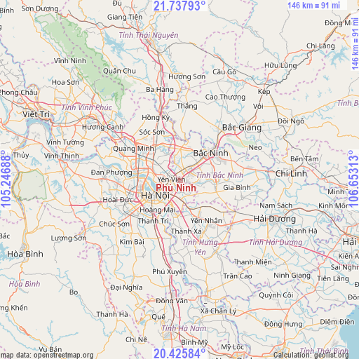
Phù Ninh GPS coordinates[2]
21° 4' 59.988" North, 105° 57' 0" East
| Map corner | latitude | longitude |
|---|---|---|
| Upper-left | 21.73793°, | 105.24688° |
| Center: | 21.08333°, | 105.95° |
| Lower-right: | 20.42584°, | 106.65313° |
| Map W x H: | 145.9×145.9 km | = 90.7×90.7mi |
| max Lat: | 23.27841° ⇑22.3% North |
| Phù Ninh: | 21.08333° |
| min Lat: | ⇓77.7% South 8.65724° |
| min Long | Phù Ninh | max Long |
| 102.4579° | 105.95° | 112.72541° |
| W 41.9%⇐ | ⇒58.1% E |
Elevation
Elevation of Phù Ninh is 9 m = 30 ft, and this is 120.5 m = 395 ft below average elevation for this country.
| Max E: |
1592 m = 5223 ft | 65.4% |
| Avg. | 129.5 m = 425 ft | |
| Phù Ninh | 9 m = 30 ft | |
Min E: |
-1 m = -3 ft | 34.6% |
See also: Vietnam elevation on elevation.city.
Geographical zone
Phù Ninh is located in North Torrid zone (between Equator and Tropic of Cancer). Distance of this Northern Tropic circle is 261.7 km =162.6 mi to North.| Distance of | km | miles | from Phù Ninh |
|---|---|---|---|
| North Pole | 7662.8 | 4761.4 | to North |
| Arctic Circle | 5056.9 | 3142.2 | to North |
| Tropic Cancer | 261.7 | 162.6 | to North |
| Equator | 2344.2 | 1456.6 | to South |


Nearby cities:
15 places around Phù Ninh: (largest is in red/bold)
• Bắc Ninh
17.4 km =10.8 mi,  48°
48°
• Chờ
12.4 km =7.7 mi,  2°
2°
• Cầu Giấy
16.5 km =10.3 mi,  249°
249°
• Hai BàTrưng
13.2 km =8.2 mi,  233°
233°
• Hanoi
13.1 km =8.1 mi,  239°
239°
• Hoàn Kiếm
12 km =7.5 mi, 239°
• Hồ
14.3 km =8.9 mi,  99°
99°
• Lim
9.9 km =6.2 mi, 47°
• Như Quỳnh
11.9 km =7.4 mi,  162°
162°
• Thanh Xuân
18.4 km =11.4 mi, 237°
• Trâu Quỳ
7.2 km =4.5 mi,  190°
190°
• Tây Hồ
14.6 km =9.1 mi,  263°
263°
• Văn Giang
15.7 km =9.8 mi, 187°
• Đông Anh
12.2 km =7.6 mi,  300°
300°
• Đống Đa
14.2 km =8.8 mi, 240°
Sources, notices
• [Note1] Compared only with cities in Vietnam existing in our database
• [Src1] Map data: © OpenStreetMap contributors (CC-BY-SA)
• [Src2] Other city data from geonames.org with taken over terms of usage.
• [Src3] Geographical zone / Annual Mean Temperature by Robert A. Rohde @ Wikipedia
