Cao Bằng geodata
Cao Bằng is a seat of a first-order administrative division; located in Vietnam in Asia/Ho_Chi_Minh (GMT+7) time zone. With population of 41,112 people, there are 62 cities with bigger population in this country. Compared to other cities in Vietnam, 96.6% of cities are located further ↓South; 54.8% of cities are located further ←West and 81.6% of cities have lower elevation than Cao Bằng. Note1


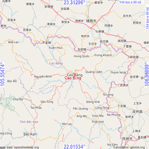
Cao Bằng GPS coordinates[2]
22° 39' 56.448" North, 106° 15' 28.296" East
| Map corner | latitude | longitude |
|---|---|---|
| Upper-left | 23.31296°, | 105.55474° |
| Center: | 22.66568°, | 106.25786° |
| Lower-right: | 22.01534°, | 106.96099° |
| Map W x H: | 144.3×144.3 km | = 89.7×89.7mi |
| max Lat: | 23.27841° ⇑3.4% North |
| Cao Bằng: | 22.66568° |
| min Lat: | ⇓96.6% South 8.65724° |
| min Long | Cao Bằng | max Long |
| 102.4579° | 106.25786° | 112.72541° |
| W 54.8%⇐ | ⇒45.2% E |
Elevation
Elevation of Cao Bằng is 197 m = 646 ft, and this is 67.5 m = 221 ft above average elevation for this country.
| Max E: |
1592 m = 5223 ft | 18.4% |
| Cao Bằng | 197 m 646 ft | |
| Avg. | 129.5 m = 425 ft | |
Min E: |
-1 m = -3 ft | 81.6% |
See also: Cao Bằng elevation on elevation.city.
Geographical zone
Cao Bằng is located in North Torrid zone (between Equator and Tropic of Cancer). Distance of this Northern Tropic circle is 85.7 km =53.3 mi to North.| Distance of | km | miles | from Cao Bằng |
|---|---|---|---|
| North Pole | 7486.9 | 4652.1 | to North |
| Arctic Circle | 4881 | 3032.9 | to North |
| Tropic Cancer | 85.7 | 53.3 | to North |
| Equator | 2520.2 | 1566 | to South |


Nearby cities:
15 places around Cao Bằng: (largest is in red/bold)
• Bộc Bố
60.9 km =37.8 mi,  264°
264°
• Phủ Thông
58.5 km =36.4 mi,  221°
221°
• Thị Trấn Hùng Quốc
19.4 km =12.1 mi,  20°
20°
• Thị Trấn Nguyên Bình
30.6 km =19 mi,  266°
266°
• Thị Trấn Nước Hai
13.5 km =8.4 mi,  306°
306°
• Thị Trấn Quảng Uyên
19.2 km =11.9 mi,  80°
80°
• Thị Trấn Thanh Nhật
42.4 km =26.3 mi,  86°
86°
• Thị Trấn Thông Nông
31.1 km =19.3 mi,  295°
295°
• Thị Trấn Thất Khê
50.7 km =31.5 mi,  154°
154°
• Thị Trấn Trùng Khánh
33.2 km =20.6 mi,  55°
55°
• Thị Trấn Tà Lùng
36.8 km =22.9 mi,  120°
120°
• Thị Trấn Xuân Hoà
32.2 km =20 mi,  324°
324°
• Thị Trấn Đông Khê
31.8 km =19.8 mi, 145°
• Vân Tùng
37.4 km =23.2 mi,  225°
225°
• Yến Lạc
48.3 km =30 mi,  189°
189°
Sources, notices
• [Note1] Compared only with cities in Vietnam existing in our database
• [Src1] Map data: © OpenStreetMap contributors (CC-BY-SA)
• [Src2] Other city data from geonames.org with taken over terms of usage.
• [Src3] Geographical zone / Annual Mean Temperature by Robert A. Rohde @ Wikipedia
