Yến Lạc geodata
Yến Lạc (Bắc Kạn) is a seat of a second-order administrative division; located in Vietnam in Asia/Ho_Chi_Minh (GMT+7) time zone. In our database, there are 94 cities with bigger population. Compared to other cities in Vietnam, 92.5% of cities are located further ↓South; 52.9% of cities are located further ←West and 83.5% of cities have lower elevation than Yến Lạc. Note1


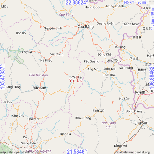
Yến Lạc GPS coordinates[2]
22° 14' 12.948" North, 106° 10' 53.364" East
| Map corner | latitude | longitude |
|---|---|---|
| Upper-left | 22.88624°, | 105.47837° |
| Center: | 22.23693°, | 106.18149° |
| Lower-right: | 21.5846°, | 106.88462° |
| Map W x H: | 144.7×144.7 km | = 89.9×89.9mi |
| max Lat: | 23.27841° ⇑7.5% North |
| Yến Lạc: | 22.23693° |
| min Lat: | ⇓92.5% South 8.65724° |
| min Long | Yến Lạc | max Long |
| 102.4579° | 106.18149° | 112.72541° |
| W 52.9%⇐ | ⇒47.1% E |
Elevation
Elevation of Yến Lạc is 252 m = 827 ft, and this is 122.5 m = 402 ft above average elevation for this country.
| Max E: |
1592 m = 5223 ft | 16.5% |
| Yến Lạc | 252 m 827 ft | |
| Avg. | 129.5 m = 425 ft | |
Min E: |
-1 m = -3 ft | 83.5% |
See also: Vietnam elevation on elevation.city.
Geographical zone
Yến Lạc is located in North Torrid zone (between Equator and Tropic of Cancer). Distance of this Northern Tropic circle is 133.4 km =82.9 mi to North.| Distance of | km | miles | from Yến Lạc |
|---|---|---|---|
| North Pole | 7534.5 | 4681.7 | to North |
| Arctic Circle | 4928.7 | 3062.6 | to North |
| Tropic Cancer | 133.4 | 82.9 | to North |
| Equator | 2472.5 | 1536.3 | to South |


Nearby cities:
15 places around Yến Lạc: (largest is in red/bold)
• Bình Gia
36 km =22.4 mi,  148°
148°
• Bắc Kạn
37.1 km =23.1 mi,  254°
254°
• Bắc Sơn
40.1 km =24.9 mi,  159°
159°
• Cao Bằng
48.3 km =30 mi,  9°
9°
• Chợ Mới
57.6 km =35.8 mi,  227°
227°
• Phủ Thông
31.3 km =19.4 mi,  277°
277°
• Thị Trấn Na Sầm
49 km =30.4 mi,  114°
114°
• Thị Trấn Nguyên Bình
51.3 km =31.9 mi,  333°
333°
• Thị Trấn Nước Hai
55.7 km =34.6 mi,  356°
356°
• Thị Trấn Quảng Uyên
57.6 km =35.8 mi,  27°
27°
• Thị Trấn Thất Khê
30.1 km =18.7 mi,  86°
86°
• Thị Trấn Tà Lùng
49.1 km =30.5 mi,  53°
53°
• Thị Trấn Đông Khê
33.5 km =20.8 mi, 50°
• Vân Tùng
28.7 km =17.8 mi,  318°
318°
• Văn Quan
55.4 km =34.4 mi,  138°
138°
Sources, notices
• [Note1] Compared only with cities in Vietnam existing in our database
• [Src1] Map data: © OpenStreetMap contributors (CC-BY-SA)
• [Src2] Other city data from geonames.org with taken over terms of usage.
• [Src3] Geographical zone / Annual Mean Temperature by Robert A. Rohde @ Wikipedia
