Tân Túc geodata
Tân Túc (Ho Chi Minh) is a seat of a second-order administrative division; located in Vietnam in Asia/Ho_Chi_Minh (GMT+7) time zone. In our database, there are 94 cities with bigger population. Compared to other cities in Vietnam, 80.8% of cities are located further ↑North; 65.3% of cities are located further ←West and 92.5% of cities have higher elevation than Tân Túc. Note1


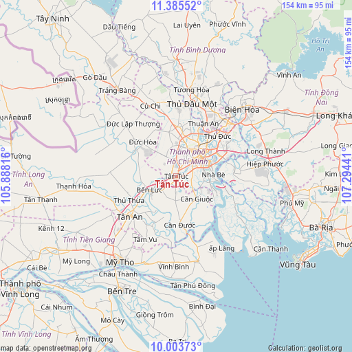
Tân Túc GPS coordinates[2]
10° 41' 43.476" North, 106° 35' 28.608" East
| Map corner | latitude | longitude |
|---|---|---|
| Upper-left | 11.38552°, | 105.88816° |
| Center: | 10.69541°, | 106.59128° |
| Lower-right: | 10.00373°, | 107.29441° |
| Map W x H: | 153.6×153.6 km | = 95.4×95.4mi |
| max Lat: | 23.27841° ⇑80.8% North |
| Tân Túc: | 10.69541° |
| min Lat: | ⇓19.2% South 8.65724° |
| min Long | Tân Túc | max Long |
| 102.4579° | 106.59128° | 112.72541° |
| W 65.3%⇐ | ⇒34.7% E |
Elevation
Elevation of Tân Túc is 4 m = 13 ft, and this is 125.5 m = 412 ft below average elevation for this country.
| Max E: |
1592 m = 5223 ft | 92.5% |
| Avg. | 129.5 m = 425 ft | |
| Tân Túc | 4 m = 13 ft | |
Min E: |
-1 m = -3 ft | 7.5% |
See also: Vietnam elevation on elevation.city.
Geographical zone
Tân Túc is located in North Torrid zone (between Equator and Tropic of Cancer). Distance of Equator is 1189.2 km =738.9 mi to South.| Distance of | km | miles | from Tân Túc |
|---|---|---|---|
| North Pole | 8817.8 | 5479.1 | to North |
| Arctic Circle | 6212 | 3860 | to North |
| Tropic Cancer | 1416.7 | 880.3 | to North |
| Equator | 1189.2 | 738.9 | to South |


Nearby cities:
15 places around Tân Túc: (largest is in red/bold)
• Cần Giuộc
13 km =8.1 mi,  137°
137°
• Ho Chi Minh City
14.8 km =9.2 mi,  16°
16°
• Nhà Bè
16.3 km =10.1 mi,  89°
89°
• Quận Ba
13.6 km =8.5 mi,  49°
49°
• Quận Bình Thạnh
16.6 km =10.3 mi,  43°
43°
• Quận Bảy
16 km =9.9 mi,  83°
83°
• Quận Bốn
14.8 km =9.2 mi,  57°
57°
• Quận Hai
20.3 km =12.6 mi, 58°
• Quận Mười
11.5 km =7.1 mi, 45°
• Quận Mười Một
9.5 km =5.9 mi, 36°
• Quận Một
15.2 km =9.4 mi, 51°
• Quận Năm
10.7 km =6.6 mi, 51°
• Quận Phú Nhuận
14.4 km =8.9 mi, 40°
• Quận Sáu
8.5 km =5.3 mi, 47°
• Quận Tân Phú
11 km =6.8 mi,  26°
26°
Sources, notices
• [Note1] Compared only with cities in Vietnam existing in our database
• [Src1] Map data: © OpenStreetMap contributors (CC-BY-SA)
• [Src2] Other city data from geonames.org with taken over terms of usage.
• [Src3] Geographical zone / Annual Mean Temperature by Robert A. Rohde @ Wikipedia
