Samatau geodata
Samatau (A'ana) is a populated place; located in Samoa in Pacific/Apia (GMT+13) time zone. With population of 939 people, there are 22 cities with bigger population in this country. Compared to other cities in Samoa, 75.4% of cities are located further ↑North; 65.6% of cities are located further →East and 78.7% of cities have higher elevation than Samatau. Note1


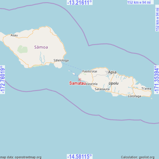
Samatau GPS coordinates[2]
13° 53' 58.704" South, 172° 3' 25.416" West
| Map corner | latitude | longitude |
|---|---|---|
| Upper-left | -13.21611°, | -172.76019° |
| Center: | -13.89964°, | -172.05706° |
| Lower-right: | -14.58115°, | -171.35394° |
| Map W x H: | 151.8×151.8 km | = 94.3×94.3mi |
| max Lat: | -13.44894° ⇑75.4% North |
| Samatau: | -13.89964° |
| min Lat: | ⇓24.6% South -14.04454° |
| min Long | Samatau | max Long |
| -172.69436° | -172.05706° | -171.42559° |
| W 34.4%⇐ | ⇒65.6% E |
Elevation
Elevation of Samatau is 10 m = 33 ft, and this is 13.9 m = 46 ft below average elevation for this country.
| Max E: |
252 m = 827 ft | 78.7% |
| Avg. | 23.9 m = 78 ft | |
| Samatau | 10 m = 33 ft | |
Min E: |
7 m = 23 ft | 21.3% |
See also: Samoa elevation on elevation.city.
Geographical zone
Samatau is located in South Torrid zone (between Equator and Tropic of Capricorn). Distance of this Southern Tropic circle is 1060.4 km =658.9 mi to South.| Distance of | km | miles | from Samatau |
|---|---|---|---|
| Equator | 1545.5 | 960.3 | to North |
| Tropic Capricorn | 1060.4 | 658.9 | to South |
| Antarctic Circle | 5855.7 | 3638.6 | to South |
| South Pole | 8461.6 | 5257.8 | to South |


Nearby cities:
15 places around Samatau: (largest is in red/bold)
• Afega
24.8 km =15.4 mi,  62°
62°
• Faleatiu
11.5 km =7.1 mi,  46°
46°
• Faleula
27 km =16.8 mi, 64°
• Fasito‘outa
15.9 km =9.9 mi, 52°
• Leulumoega
13.4 km =8.3 mi, 50°
• Levī
5.2 km =3.2 mi,  107°
107°
• Lotofagā
23.1 km =14.4 mi, 111°
• Malie
25.2 km =15.7 mi, 64°
• Mulifanua
7.9 km =4.9 mi,  16°
16°
• Nofoali‘i
13.7 km =8.5 mi, 50°
• Pata
4 km =2.5 mi, 108°
• Salepou‘a‘e
20.6 km =12.8 mi, 58°
• Sapulu
18 km =11.2 mi, 54°
• Satapuala
11 km =6.8 mi, 49°
• Tufulele
18.5 km =11.5 mi, 55°
Sources, notices
• [Note1] Compared only with cities in Samoa existing in our database
• [Src1] Map data: © OpenStreetMap contributors (CC-BY-SA)
• [Src2] Other city data from geonames.org with taken over terms of usage.
• [Src3] Geographical zone / Annual Mean Temperature by Robert A. Rohde @ Wikipedia
