Gjakovë geodata
Gjakovë (Gjakova) is a seat of a first-order administrative division; located in Kosovo in Europe/Belgrade (GMT+2) time zone. With population of 94,158 people, there are 3 cities with bigger population in this country. Compared to other cities in Kosovo, 80% of cities are located further ↑North; 67.7% of cities are located further →East and 98.5% of cities have higher elevation than Gjakovë. Note1


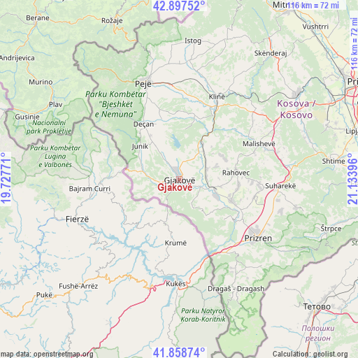
Gjakovë GPS coordinates[2]
42° 22' 49.008" North, 20° 25' 50.988" East
| Map corner | latitude | longitude |
|---|---|---|
| Upper-left | 42.89752°, | 19.72771° |
| Center: | 42.38028°, | 20.43083° |
| Lower-right: | 41.85874°, | 21.13396° |
| Map W x H: | 115.5×115.5 km | = 71.8×71.8mi |
| max Lat: | 43.10389° ⇑80% North |
| Gjakovë: | 42.38028° |
| min Lat: | ⇓20% South 42.0265° |
| min Long | Gjakovë | max Long |
| 20.27722° | 20.43083° | 21.59889° |
| W 32.3%⇐ | ⇒67.7% E |
Elevation
Elevation of Gjakovë is 362 m = 1188 ft, and this is 182.6 m = 599 ft below average elevation for this country.
| Max E: |
1062 m = 3484 ft | 98.5% |
| Avg. | 544.6 m = 1787 ft | |
| Gjakovë | 362 m = 1188 ft | |
Min E: |
333 m = 1093 ft | 1.5% |
See also: Gjakovë elevation on elevation.city.
Geographical zone
Gjakovë is located in North temperate zone (between Tropic of Cancer and the Arctic Circle). Distance of this Northern Tropic circle is 2106.3 km =1308.8 mi to South.| Distance of | km | miles | from Gjakovë |
|---|---|---|---|
| North Pole | 5294.8 | 3290 | to North |
| Arctic Circle | 2688.9 | 1670.8 | to North |
| Tropic Cancer | 2106.3 | 1308.8 | to South |
| Equator | 4712.2 | 2928 | to South |


Nearby cities:
15 places around Gjakovë: (largest is in red/bold)
• Buqan
19.8 km =12.3 mi,  5°
5°
• Dranoc
18.9 km =11.7 mi,  322°
322°
• Gllogjan
15.2 km =9.4 mi,  338°
338°
• Irzniq
17 km =10.6 mi, 336°
• Junik
16.5 km =10.3 mi,  310°
310°
• Lloqan
20.2 km =12.6 mi, 322°
• Lluka e Eperme
20.9 km =13 mi,  331°
331°
• Lluka e Poshtme
20 km =12.4 mi, 336°
• Lumbardhi
19.7 km =12.2 mi, 339°
• Orahovac
18.5 km =11.5 mi,  83°
83°
• Papraqan
20.9 km =13 mi, 336°
• Pozhar
18.6 km =11.6 mi, 339°
• Prilep
16.9 km =10.5 mi, 326°
• Shaptej
13.8 km =8.6 mi, 342°
• Slup
18.8 km =11.7 mi, 319°
Sources, notices
• [Note1] Compared only with cities in Kosovo existing in our database
• [Src1] Map data: © OpenStreetMap contributors (CC-BY-SA)
• [Src2] Other city data from geonames.org with taken over terms of usage.
• [Src3] Geographical zone / Annual Mean Temperature by Robert A. Rohde @ Wikipedia
