Raşad geodata
Raşad (Abyan) is a seat of a second-order administrative division; located in Yemen in Asia/Aden (GMT+3) time zone. In our database, there are 51 cities with bigger population. Compared to other cities in Yemen, 85.4% of cities are located further ↑North; 71.4% of cities are located further ←West and 62.3% of cities have lower elevation than Raşad. Note1


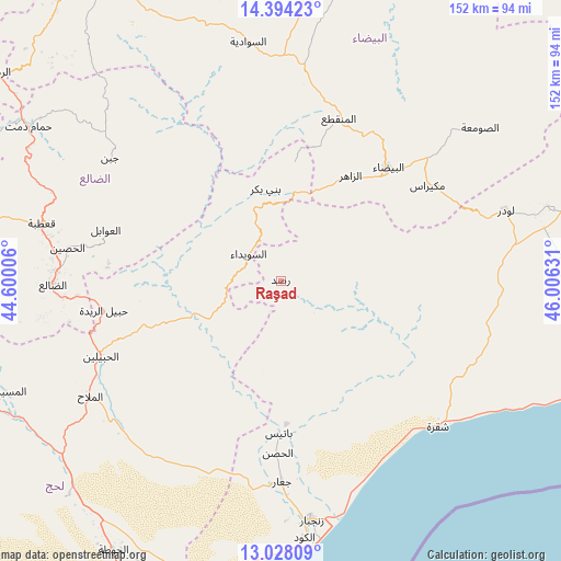
Raşad GPS coordinates[2]
13° 42' 43.74" North, 45° 18' 11.448" East
| Map corner | latitude | longitude |
|---|---|---|
| Upper-left | 14.39423°, | 44.60006° |
| Center: | 13.71215°, | 45.30318° |
| Lower-right: | 13.02809°, | 46.00631° |
| Map W x H: | 151.9×151.9 km | = 94.4×94.4mi |
| max Lat: | 17.76999° ⇑85.4% North |
| Raşad: | 13.71215° |
| min Lat: | ⇓14.6% South 12.18576° |
| min Long | Raşad | max Long |
| 42.67107° | 45.30318° | 54.01895° |
| W 71.4%⇐ | ⇒28.6% E |
Elevation
Elevation of Raşad is 1657 m = 5436 ft, and this is 352.2 m = 1156 ft above average elevation for this country.
| Max E: |
2791 m = 9157 ft | 37.7% |
| Raşad | 1657 m 5436 ft | |
| Avg. | 1304.8 m = 4281 ft | |
Min E: |
4 m = 13 ft | 62.3% |
See also: Yemen elevation on elevation.city.
Geographical zone
Raşad is located in North Torrid zone (between Equator and Tropic of Cancer). Distance of this Northern Tropic circle is 1081.3 km =671.9 mi to North.| Distance of | km | miles | from Raşad |
|---|---|---|---|
| North Pole | 8482.4 | 5270.7 | to North |
| Arctic Circle | 5876.5 | 3651.5 | to North |
| Tropic Cancer | 1081.3 | 671.9 | to North |
| Equator | 1524.6 | 947.3 | to South |


Nearby cities:
15 places around Raşad: (largest is in red/bold)
• Al Bayda
42.1 km =26.2 mi,  43°
43°
• Al Jurbah
17.9 km =11.1 mi,  299°
299°
• Al Ḩabīlayn
53.4 km =33.2 mi,  246°
246°
• Al ‘Awābil
49.4 km =30.7 mi,  286°
286°
• As Suwaydā
11.4 km =7.1 mi,  316°
316°
• Az Zāhir
34.3 km =21.3 mi,  34°
34°
• Banī Bakr
24.9 km =15.5 mi,  350°
350°
• Dhī Nā‘im
46.5 km =28.9 mi,  19°
19°
• Ja‘ār
54.4 km =33.8 mi,  179°
179°
• Madīnat Lab‘ūs
18.1 km =11.2 mi,  341°
341°
• Mukayrās
47.3 km =29.4 mi,  56°
56°
• Sirār
8.3 km =5.2 mi,  172°
172°
• Sūq Sibāḩ
14.9 km =9.3 mi, 40°
• Ḩabīl al Jabr
36.3 km =22.6 mi, 250°
• Ḩabīl ar Raydah
49.4 km =30.7 mi,  261°
261°
Sources, notices
• [Note1] Compared only with cities in Yemen existing in our database
• [Src1] Map data: © OpenStreetMap contributors (CC-BY-SA)
• [Src2] Other city data from geonames.org with taken over terms of usage.
• [Src3] Geographical zone / Annual Mean Temperature by Robert A. Rohde @ Wikipedia
