Al Bayda geodata
Al Bayda is a seat of a first-order administrative division; located in Yemen in Asia/Aden (GMT+3) time zone. With population of 37,821 people, there are 14 cities with bigger population in this country. Compared to other cities in Yemen, 75.3% of cities are located further ↑North; 75.6% of cities are located further ←West and 74% of cities have lower elevation than Al Bayda. Note1


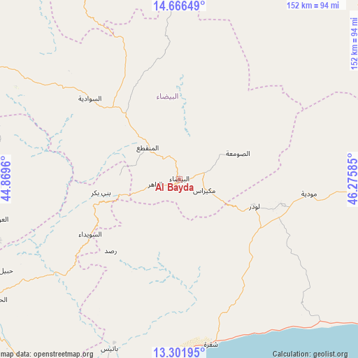
Al Bayda GPS coordinates[2]
13° 59' 6.828" North, 45° 34' 21.792" East
| Map corner | latitude | longitude |
|---|---|---|
| Upper-left | 14.66649°, | 44.8696° |
| Center: | 13.98523°, | 45.57272° |
| Lower-right: | 13.30195°, | 46.27585° |
| Map W x H: | 151.7×151.7 km | = 94.3×94.3mi |
| max Lat: | 17.76999° ⇑75.3% North |
| Al Bayda: | 13.98523° |
| min Lat: | ⇓24.7% South 12.18576° |
| min Long | Al Bayda | max Long |
| 42.67107° | 45.57272° | 54.01895° |
| W 75.6%⇐ | ⇒24.4% E |
Elevation
Elevation of Al Bayda is 2005 m = 6578 ft, and this is 700.2 m = 2297 ft above average elevation for this country.
| Max E: |
2791 m = 9157 ft | 26% |
| Al Bayda | 2005 m 6578 ft | |
| Avg. | 1304.8 m = 4281 ft | |
Min E: |
4 m = 13 ft | 74% |
See also: Yemen elevation on elevation.city.
Geographical zone
Al Bayda is located in North Torrid zone (between Equator and Tropic of Cancer). Distance of this Northern Tropic circle is 1050.9 km =653 mi to North.| Distance of | km | miles | from Al Bayda |
|---|---|---|---|
| North Pole | 8452.1 | 5251.9 | to North |
| Arctic Circle | 5846.2 | 3632.7 | to North |
| Tropic Cancer | 1050.9 | 653 | to North |
| Equator | 1555 | 966.2 | to South |


Nearby cities:
15 places around Al Bayda: (largest is in red/bold)
• Al Jurbah
49.6 km =30.8 mi,  244°
244°
• As Suwaydā
43 km =26.7 mi, 239°
• Az Zāhir
9.9 km =6.2 mi,  257°
257°
• Aş Şawma‘ah
27 km =16.8 mi,  65°
65°
• Banī Bakr
33.5 km =20.8 mi, 260°
• Dhī Nā‘im
19 km =11.8 mi,  314°
314°
• Jawf al Maqbābah
32.7 km =20.3 mi,  120°
120°
• Lawdar
33.9 km =21.1 mi,  109°
109°
• Madīnat Lab‘ūs
37.2 km =23.1 mi,  249°
249°
• Maswarah
43.2 km =26.8 mi,  22°
22°
• Mukayrās
11.5 km =7.1 mi, 113°
• Raşad
42.1 km =26.2 mi,  223°
223°
• Sirār
47.7 km =29.6 mi, 215°
• Sūq Sibāḩ
27.2 km =16.9 mi,  225°
225°
• Āl Ma‘ūdah
32.1 km =19.9 mi,  321°
321°
Sources, notices
• [Note1] Compared only with cities in Yemen existing in our database
• [Src1] Map data: © OpenStreetMap contributors (CC-BY-SA)
• [Src2] Other city data from geonames.org with taken over terms of usage.
• [Src3] Geographical zone / Annual Mean Temperature by Robert A. Rohde @ Wikipedia
