Atlantis geodata
Atlantis (Western Cape) is a populated place; located in South Africa in Africa/Johannesburg (GMT+2) time zone. With population of 60,266 people, there are 83 cities with bigger population in this country. Compared to other cities in South Africa, 89.1% of cities are located further ↑North; 96.2% of cities are located further →East and 84.1% of cities have higher elevation than Atlantis. Note1
Administrative division(s):
- Level 1: Western Cape
- Level 2: City of Cape Town
- Level 3: City of Cape Town


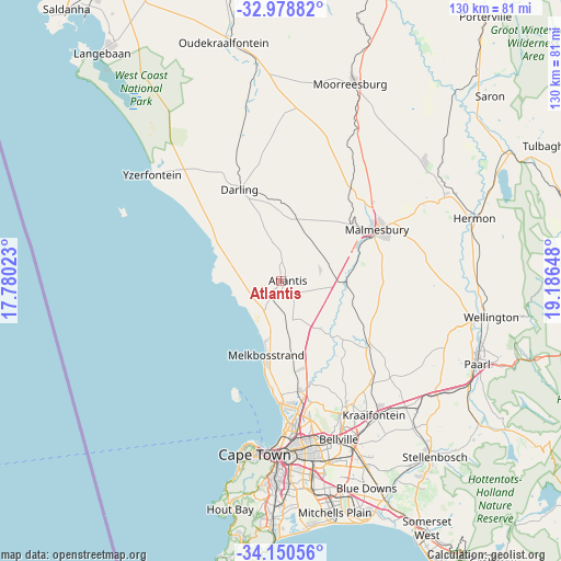
Atlantis GPS coordinates[2]
33° 34' 0.048" South, 18° 29' 0.06" East
| Map corner | latitude | longitude |
|---|---|---|
| Upper-left | -32.97882°, | 17.78023° |
| Center: | -33.56668°, | 18.48335° |
| Lower-right: | -34.15056°, | 19.18648° |
| Map W x H: | 130.3×130.3 km | = 81×81mi |
| max Lat: | -22.34881° ⇑89.1% North |
| Atlantis: | -33.56668° |
| min Lat: | ⇓10.9% South -34.66739° |
| min Long | Atlantis | max Long |
| 16.8697° | 18.48335° | 32.26762° |
| W 3.8%⇐ | ⇒96.2% E |
Elevation
Elevation of Atlantis is 178 m = 584 ft, and this is 791.6 m = 2597 ft below average elevation for this country.
| Max E: |
1873 m = 6145 ft | 84.1% |
| Avg. | 969.6 m = 3181 ft | |
| Atlantis | 178 m = 584 ft | |
Min E: |
7 m = 23 ft | 15.9% |
See also: Atlantis elevation on elevation.city.
Geographical zone
Atlantis is located in South temperate zone (between Tropic of Capricorn and the Antarctic Circle). Distance of this Southern Tropic circle is 1126.3 km =699.9 mi to North.| Distance of | km | miles | from Atlantis |
|---|---|---|---|
| Equator | 3732.3 | 2319.1 | to North |
| Tropic Capricorn | 1126.3 | 699.9 | to North |
| Antarctic Circle | 3668.9 | 2279.7 | to South |
| South Pole | 6274.8 | 3899 | to South |


Nearby cities:
15 places around Atlantis: (largest is in red/bold)
• Bergvliet
53.5 km =33.2 mi,  183°
183°
• Cape Town
40.3 km =25 mi,  187°
187°
• Claremont
46 km =28.6 mi, 182°
• Constantia
52 km =32.3 mi, 186°
• Kraaifontein
38 km =23.6 mi,  145°
145°
• Lansdowne
46.8 km =29.1 mi, 178°
• Malmesbury
25.5 km =15.8 mi,  62°
62°
• Moorreesburg
48.8 km =30.3 mi,  19°
19°
• Newlands
45.9 km =28.5 mi, 184°
• Paarl
49.2 km =30.6 mi,  112°
112°
• Rondebosch
44.1 km =27.4 mi, 180°
• Rosebank
43.2 km =26.8 mi, 181°
• Stellenbosch
54.1 km =33.6 mi,  139°
139°
• Sunset Beach
32 km =19.9 mi, 178°
• Wellington
49.6 km =30.8 mi,  99°
99°
Sources, notices
• [Note1] Compared only with cities in South Africa existing in our database
• [Src1] Map data: © OpenStreetMap contributors (CC-BY-SA)
• [Src2] Other city data from geonames.org with taken over terms of usage.
• [Src3] Geographical zone / Annual Mean Temperature by Robert A. Rohde @ Wikipedia
