Stellenbosch geodata
Stellenbosch (Western Cape) is a seat of a third-order administrative division; located in South Africa in Africa/Johannesburg (GMT+2) time zone. With population of 94,263 people, there are 56 cities with bigger population in this country. Compared to other cities in South Africa, 93.2% of cities are located further ↑North; 93.8% of cities are located further →East and 86.4% of cities have higher elevation than Stellenbosch. Note1
Administrative division(s):
- Level 1: Western Cape
- Level 2: Cape Winelands District Municipality
- Level 3: Stellenbosch


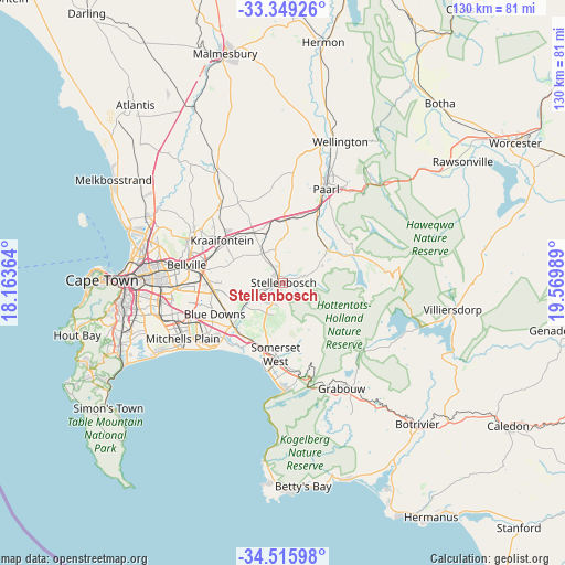
Stellenbosch GPS coordinates[2]
33° 56' 4.632" South, 18° 52' 0.336" East
| Map corner | latitude | longitude |
|---|---|---|
| Upper-left | -33.34926°, | 18.16364° |
| Center: | -33.93462°, | 18.86676° |
| Lower-right: | -34.51598°, | 19.56989° |
| Map W x H: | 129.7×129.7 km | = 80.6×80.6mi |
| max Lat: | -22.34881° ⇑93.2% North |
| Stellenbosch: | -33.93462° |
| min Lat: | ⇓6.8% South -34.66739° |
| min Long | Stellenbosch | max Long |
| 16.8697° | 18.86676° | 32.26762° |
| W 6.2%⇐ | ⇒93.8% E |
Elevation
Elevation of Stellenbosch is 122 m = 400 ft, and this is 847.6 m = 2781 ft below average elevation for this country.
| Max E: |
1873 m = 6145 ft | 86.4% |
| Avg. | 969.6 m = 3181 ft | |
| Stellenbosch | 122 m = 400 ft | |
Min E: |
7 m = 23 ft | 13.6% |
See also: Stellenbosch elevation on elevation.city.
Geographical zone
Stellenbosch is located in South temperate zone (between Tropic of Capricorn and the Antarctic Circle). Distance of this Southern Tropic circle is 1167.3 km =725.3 mi to North.| Distance of | km | miles | from Stellenbosch |
|---|---|---|---|
| Equator | 3773.2 | 2344.6 | to North |
| Tropic Capricorn | 1167.3 | 725.3 | to North |
| Antarctic Circle | 3628 | 2254.3 | to South |
| South Pole | 6233.9 | 3873.6 | to South |


Nearby cities:
15 places around Stellenbosch: (largest is in red/bold)
• Atlantis
54.1 km =33.6 mi,  319°
319°
• Bergvliet
40.2 km =25 mi,  251°
251°
• Cape Town
40.9 km =25.4 mi,  271°
271°
• Claremont
37.4 km =23.2 mi,  262°
262°
• Constantia
42.7 km =26.5 mi, 255°
• Grabouw
27.7 km =17.2 mi,  150°
150°
• Kraaifontein
16.8 km =10.4 mi,  304°
304°
• Lansdowne
34.6 km =21.5 mi, 260°
• Newlands
38.9 km =24.2 mi, 262°
• Paarl
24.5 km =15.2 mi,  24°
24°
• Retreat
38.4 km =23.9 mi, 249°
• Rondebosch
36.1 km =22.4 mi, 264°
• Rosebank
36.3 km =22.6 mi, 266°
• Sunset Beach
35.7 km =22.2 mi,  284°
284°
• Wellington
35.4 km =22 mi, 22°
Sources, notices
• [Note1] Compared only with cities in South Africa existing in our database
• [Src1] Map data: © OpenStreetMap contributors (CC-BY-SA)
• [Src2] Other city data from geonames.org with taken over terms of usage.
• [Src3] Geographical zone / Annual Mean Temperature by Robert A. Rohde @ Wikipedia
