Malmesbury geodata
Malmesbury (Western Cape) is a seat of a third-order administrative division; located in South Africa in Africa/Johannesburg (GMT+2) time zone. With population of 34,991 people, there are 112 cities with bigger population in this country. Compared to other cities in South Africa, 87.6% of cities are located further ↑North; 94.4% of cities are located further →East and 85% of cities have higher elevation than Malmesbury. Note1
Administrative division(s):
- Level 1: Western Cape
- Level 2: West Coast District Municipality
- Level 3: Swartland


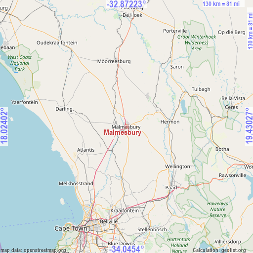
Malmesbury GPS coordinates[2]
33° 27' 38.88" South, 18° 43' 37.704" East
| Map corner | latitude | longitude |
|---|---|---|
| Upper-left | -32.87223°, | 18.02402° |
| Center: | -33.4608°, | 18.72714° |
| Lower-right: | -34.0454°, | 19.43027° |
| Map W x H: | 130.4×130.4 km | = 81×81mi |
| max Lat: | -22.34881° ⇑87.6% North |
| Malmesbury: | -33.4608° |
| min Lat: | ⇓12.4% South -34.66739° |
| min Long | Malmesbury | max Long |
| 16.8697° | 18.72714° | 32.26762° |
| W 5.6%⇐ | ⇒94.4% E |
Elevation
Elevation of Malmesbury is 136 m = 446 ft, and this is 833.6 m = 2735 ft below average elevation for this country.
| Max E: |
1873 m = 6145 ft | 85% |
| Avg. | 969.6 m = 3181 ft | |
| Malmesbury | 136 m = 446 ft | |
Min E: |
7 m = 23 ft | 15% |
See also: South Africa elevation on elevation.city.
Geographical zone
Malmesbury is located in South temperate zone (between Tropic of Capricorn and the Antarctic Circle). Distance of this Southern Tropic circle is 1114.6 km =692.6 mi to North.| Distance of | km | miles | from Malmesbury |
|---|---|---|---|
| Equator | 3720.5 | 2311.8 | to North |
| Tropic Capricorn | 1114.6 | 692.6 | to North |
| Antarctic Circle | 3680.7 | 2287.1 | to South |
| South Pole | 6286.6 | 3906.3 | to South |


Nearby cities:
15 places around Malmesbury: (largest is in red/bold)
• Atlantis
25.5 km =15.8 mi,  242°
242°
• Cape Town
58.9 km =36.6 mi,  208°
208°
• Ceres
55.1 km =34.2 mi,  79°
79°
• Claremont
62.7 km =39 mi,  202°
202°
• Kraaifontein
43.1 km =26.8 mi,  181°
181°
• Lansdowne
62.3 km =38.7 mi, 199°
• Moorreesburg
34.7 km =21.6 mi,  349°
349°
• Newlands
63.1 km =39.2 mi, 204°
• Paarl
38.1 km =23.7 mi,  142°
142°
• Piketberg
62.1 km =38.6 mi,  2°
2°
• Rondebosch
60.5 km =37.6 mi, 202°
• Rosebank
59.8 km =37.2 mi, 203°
• Stellenbosch
54.2 km =33.7 mi,  166°
166°
• Sunset Beach
48.8 km =30.3 mi, 206°
• Wellington
33 km =20.5 mi,  127°
127°
Sources, notices
• [Note1] Compared only with cities in South Africa existing in our database
• [Src1] Map data: © OpenStreetMap contributors (CC-BY-SA)
• [Src2] Other city data from geonames.org with taken over terms of usage.
• [Src3] Geographical zone / Annual Mean Temperature by Robert A. Rohde @ Wikipedia
