Paarl geodata
Paarl (Western Cape) is a seat of a third-order administrative division; located in South Africa in Africa/Johannesburg (GMT+2) time zone. With population of 190,000 people, there are 26 cities with bigger population in this country. Compared to other cities in South Africa, 90.6% of cities are located further ↑North; 93.2% of cities are located further →East and 87.9% of cities have higher elevation than Paarl. Note1
Administrative division(s):
- Level 1: Western Cape
- Level 2: Cape Winelands District Municipality
- Level 3: Drakenstein


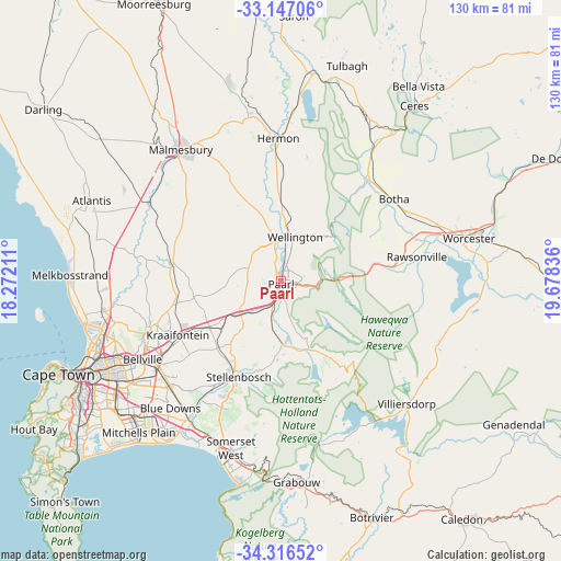
Paarl GPS coordinates[2]
33° 44' 1.608" South, 18° 58' 30.828" East
| Map corner | latitude | longitude |
|---|---|---|
| Upper-left | -33.14706°, | 18.27211° |
| Center: | -33.73378°, | 18.97523° |
| Lower-right: | -34.31652°, | 19.67836° |
| Map W x H: | 130×130 km | = 80.8×80.8mi |
| max Lat: | -22.34881° ⇑90.6% North |
| Paarl: | -33.73378° |
| min Lat: | ⇓9.4% South -34.66739° |
| min Long | Paarl | max Long |
| 16.8697° | 18.97523° | 32.26762° |
| W 6.8%⇐ | ⇒93.2% E |
Elevation
Elevation of Paarl is 107 m = 351 ft, and this is 862.6 m = 2830 ft below average elevation for this country.
| Max E: |
1873 m = 6145 ft | 87.9% |
| Avg. | 969.6 m = 3181 ft | |
| Paarl | 107 m = 351 ft | |
Min E: |
7 m = 23 ft | 12.1% |
See also: Paarl elevation on elevation.city.
Geographical zone
Paarl is located in South temperate zone (between Tropic of Capricorn and the Antarctic Circle). Distance of this Southern Tropic circle is 1144.9 km =711.4 mi to North.| Distance of | km | miles | from Paarl |
|---|---|---|---|
| Equator | 3750.8 | 2330.6 | to North |
| Tropic Capricorn | 1144.9 | 711.4 | to North |
| Antarctic Circle | 3650.3 | 2268.2 | to South |
| South Pole | 6256.2 | 3887.4 | to South |


Nearby cities:
15 places around Paarl: (largest is in red/bold)
• Atlantis
49.2 km =30.6 mi,  292°
292°
• Cape Town
55.3 km =34.4 mi,  247°
247°
• Ceres
51.1 km =31.8 mi,  37°
37°
• Claremont
54.5 km =33.9 mi,  239°
239°
• Grabouw
46.6 km =29 mi,  175°
175°
• Kraaifontein
27 km =16.8 mi, 241°
• Lansdowne
52.4 km =32.6 mi, 237°
• Malmesbury
38.1 km =23.7 mi,  322°
322°
• Newlands
55.8 km =34.7 mi, 240°
• Rondebosch
52.7 km =32.7 mi, 241°
• Rosebank
52.4 km =32.6 mi, 241°
• Stellenbosch
24.5 km =15.2 mi,  204°
204°
• Sunset Beach
46.6 km =29 mi, 253°
• Wellington
11 km =6.8 mi,  17°
17°
• Worcester
44.8 km =27.8 mi,  77°
77°
Sources, notices
• [Note1] Compared only with cities in South Africa existing in our database
• [Src1] Map data: © OpenStreetMap contributors (CC-BY-SA)
• [Src2] Other city data from geonames.org with taken over terms of usage.
• [Src3] Geographical zone / Annual Mean Temperature by Robert A. Rohde @ Wikipedia
